One moment please, your device is loading the charts...
Population numbers in the municipality Cramonshagen for the years 2012 thru 2019.
The number of inhabitants is the number of persons as registered in the population register on January 1st.
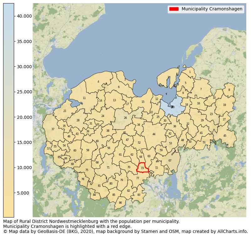
Map of Rural district Nordwestmecklenburg with the population per municipality.Municipality Cramonshagen is highlighted with a red edge. The numbers at the map represent the following municipalities: 1: municipality Boiensdorf, 2: municipality Insel Poel, 3: municipality Boltenhagen, 4: municipality Kalkhorst, 5: municipality Blowatz ...Show more... Map of Rural district Nordwestmecklenburg with the population per municipality.Municipality Cramonshagen is highlighted with a red edge. The numbers at the map represent the following municipalities: 1: municipality Boiensdorf, 2: municipality Insel Poel, 3: municipality Boltenhagen, 4: municipality Kalkhorst, 5: municipality Blowatz, 6: municipality city Klütz, 7: municipality Neuburg, 8: municipality Passee, 9: municipality Krusenhagen, 10: municipality Züsow, 11: municipality city Dassow, 12: municipality Zierow, 13: municipality Damshagen, 14: municipality Roggenstorf, 15: municipality Hohenkirchen, 16: municipality Benz, 17: municipality Warnow, 18: municipality Hornstorf, 19: municipality Glasin, 20: municipality city Wismar, 21: municipality Selmsdorf, 22: municipality Gägelow, 23: municipality city Neukloster, 24: municipality Stepenitztal, 25: municipality Barnekow, 26: municipality city Grevesmühlen, 27: municipality Lübberstorf, 28: municipality city Schönberg, 29: municipality Zurow, 30: municipality Metelsdorf, 31: municipality Menzendorf, 32: municipality Lübow, 33: municipality Grieben, 34: municipality Plüschow, 35: municipality Lockwisch, 36: municipality Dorf Mecklenburg, 37: municipality Lüdersdorf, 38: municipality Bernstorf, 39: municipality Roduchelstorf, 40: municipality Upahl, 41: municipality Jesendorf, 42: municipality Groß Stieten, 43: municipality Groß Siemz, 44: municipality Bobitz, 45: municipality city Warin, 46: municipality Niendorf, 47: municipality Rüting, 48: municipality Hohen Viecheln, 49: municipality city Rehna, 50: municipality Ventschow, 51: municipality Bibow, 52: municipality Testorf-Steinfort, 53: municipality Bad Kleinen, 54: municipality Rieps, 55: municipality Thandorf, 56: municipality Wedendorfersee, 57: municipality Utecht, 58: municipality Königsfeld, 59: municipality Zickhusen, 60: municipality Carlow, 61: municipality Veelböken, 62: municipality Mühlen Eichsen, 63: municipality Alt Meteln, 64: municipality Dalberg-Wendelstorf, 65: municipality Schlagsdorf, 66: municipality Groß Molzahn, 67: municipality Lübstorf, 68: municipality Holdorf, 69: municipality Dechow, 70: municipality Dragun, 71: municipality city Gadebusch, 72: municipality Klein Trebbow, 73: municipality Cramonshagen, 74: municipality Seehof, 75: municipality Roggendorf, 76: municipality Pingelshagen, 77: municipality Brüsewitz, 78: municipality Kneese, 79: municipality Lützow, 80: municipality Pokrent, 81: municipality Krembz, 82: municipality Gottesgabe, 83: municipality Grambow, 84: municipality Rögnitz, 85: municipality Schildetal, 86: municipality Perlin ...Show less...
One moment please, your device is loading the charts...
Municipality Cramonshagen, 2019, number of rooms per house.
The percentage shows the relative share of houses per category based on the numer of rooms: 1 to 2 rooms, 3 to 4 rooms or 5 rooms or more. This is based on the total number of rooms as identified for all dwellings in the municipality Cramonshagen.
The table below shows data for more than 100 topics as most recently available for the municipality Cramonshagen. Select a category to display the related topics:
| Business | Value | Unit | Year |
|---|---|---|---|
| Businesses | 1 | Number | 2017 |
| Active persons | 0 | Number | 2017 |
| Gross wages | €0 | Euro | 2017 |
| Dwellings | Value | Unit | Year |
|---|---|---|---|
| Houses 1 room | 0 | Number | 2019 |
| Houses 2 rooms | 4 | Number | 2019 |
| Houses 3 rooms | 17 | Number | 2019 |
| Houses 4 rooms | 62 | Number | 2019 |
| Houses 5 rooms | 67 | Number | 2019 |
| Houses 6 rooms | 58 | Number | 2019 |
| Houses 7+ rooms | 34 | Number | 2019 |
| Houses 1-2 rooms | 4 | Number | 2019 |
| Houses 3-4 rooms | 79 | Number | 2019 |
| Houses 5+ rooms | 159 | Number | 2019 |
| 1-2 rooms | 2% | Percentage | 2019 |
| 3-4 rooms | 33% | Percentage | 2019 |
| 5+ rooms | 66% | Percentage | 2019 |
| Elections | Value | Unit | Year |
|---|---|---|---|
| Voters Bundestag | 438,00 | Number | 2017 |
| Voter turnout Bundestag | 63 | Number | 2017 |
| Votes valid Bundestag | 274 | Number | 2017 |
| Votes Bundestag CDU/CSU | 89 | Number | 2017 |
| Votes Bundestag SPD | 51 | Number | 2017 |
| Votes Bundestag GRÜNE | 7 | Number | 2017 |
| Votes Bundestag FDP | 24 | Number | 2017 |
| Votes Bundestag DIE LINKE | 41 | Number | 2017 |
| Votes Bundestag AfD | 55 | Number | 2017 |
| Votes Bundestag other parties | 7 | Number | 2017 |
| Votes Bundestag total | 274 | Number | 2017 |
| % Votes Bundestag CDU/CSU | 20% | Percentage | 2017 |
| % Votes Bundestag SPD | 12% | Percentage | 2017 |
| % Votes Bundestag GRÜNE | 2% | Percentage | 2017 |
| % Votes Bundestag FDP | 5% | Percentage | 2017 |
| % Votes Bundestag DIE LINKE | 9% | Percentage | 2017 |
| % Votes Bundestag AfD | 13% | Percentage | 2017 |
| % Votes Bundestag other parties | 2% | Percentage | 2017 |
| Employment | Value | Unit | Year |
|---|---|---|---|
| Employees | 207 | Number | 2019 |
| Employees male | 111 | Number | 2019 |
| Employees female | 96 | Number | 2019 |
| Employees foreigner | 0 | Number | 2019 |
| Employees male foreigner | 0 | Number | 2019 |
| Employees female foreigner | 0 | Number | 2019 |
| Unemployed | 13 | Number | 2018 |
| Unemployed foreigners | 0 | Number | 2018 |
| Unemployed severely disabled | 1 | Number | 2018 |
| Unemployed 15-20 | 1 | Number | 2018 |
| Unemployed 15-25 | 2 | Number | 2018 |
| Unemployed 55-65 | 7 | Number | 2018 |
| Unemployed long-term | 4 | Number | 2018 |
| % Unemployed | 3% | Percentage | 2018 |
| % Unemployed foreigners | 0% | Percentage of the population | 2018 |
| % Unemployed severely disabled | 0% | Percentage of the population | 2018 |
| % Unemployed 15-20 | 0% | Percentage of the population | 2018 |
| % Unemployed 15-25 | 0% | Percentage of the population | 2018 |
| % Unemployed 55-65 | 1% | Percentage of the population | 2018 |
| % Unemployed long-term | 1% | Percentage of the population | 2018 |
| Income | Value | Unit | Year |
|---|---|---|---|
| Income receivers | 234 | Number | 2015 |
| Income total | €10.116 | Euro | 2015 |
| Income tax | €1.689 | Euro | 2015 |
| Population | Value | Unit | Year |
|---|---|---|---|
| Population | 519 | Number | 2019 |
| Men | 269 | Number | 2019 |
| Women | 250 | Number | 2019 |
| % Men | 52% | Percentage | 2019 |
| % Women | 48% | Percentage | 2019 |
| 0-18 | 64 | Number | 2019 |
| 18-30 | 27 | Number | 2019 |
| 30-45 | 96 | Number | 2019 |
| 45-60 | 147 | Number | 2019 |
| 18-60 | 270 | Number | 2019 |
| 60-75 | 132 | Number | 2019 |
| 60+ | 185 | Number | 2019 |
| Average age | 49 | Average number | 2019 |
| Average age male | 48 | Average number | 2019 |
| Average age female | 50 | Average number | 2019 |
| Births | 4 | Number | 2018 |
| Births male | 2 | Number | 2018 |
| Births female | 2 | Number | 2018 |
| 1K Births | 8 | Number per 1000 inhabitants | 2018 |
| Deaths | no data | Number | 2017 |
| Deaths male | no data | Number | 2017 |
| Deaths female | no data | Number | 2017 |
| 1K Deaths | no data | Number | 2017 |
| 0-3 | 15 | Number | 2019 |
| Girls 0-3 | 7 | Number | 2019 |
| Boys 0-3 | 8 | Number | 2019 |
| 3-6 | 12 | Number | 2019 |
| Girls 3-6 | 7 | Number | 2019 |
| Boys 3-6 | 5 | Number | 2019 |
| 6-10 | 13 | Number | 2019 |
| 10-15 | 18 | Number | 2019 |
| 15-18 | 6 | Number | 2019 |
| 18-20 | 9 | Number | 2019 |
| 20-25 | 8 | Number | 2019 |
| 25-30 | 10 | Number | 2019 |
| 30-35 | 40 | Number | 2019 |
| 35-40 | 28 | Number | 2019 |
| 40-45 | 28 | Number | 2019 |
| 45-50 | 34 | Number | 2019 |
| 50-55 | 51 | Number | 2019 |
| 55-60 | 62 | Number | 2019 |
| 60-65 | 49 | Number | 2019 |
| 65-75 | 83 | Number | 2019 |
| Women 65-70 | 32 | Number | 2019 |
| Men 65-70 | 51 | Number | 2019 |
| 75+ | 53 | Number | 2019 |
| Women 75+ | 33 | Number | 2019 |
| Men 75+ | 20 | Number | 2019 |
| % 0-10 | 8% | Percentage | 2019 |
| % 10-18 | 5% | Percentage | 2019 |
| % 18-30 | 5% | Percentage | 2019 |
| % 30-45 | 18% | Percentage | 2019 |
| % 45-60 | 28% | Percentage | 2019 |
| % 60+ | 36% | Percentage | 2019 |
| Real estate | Value | Unit | Year |
|---|---|---|---|
| Property tax A revenue | no data | Euro | no data |
| Property tax B revenue | no data | Euro | no data |
| Trade tax actual revenue | no data | Euro | no data |
| Property tax A basic amount | no data | Euro | no data |
| Property tax B basic amount | no data | Euro | no data |
| Trade tax basic amount | no data | Euro | no data |
| Property tax A rate | no data | Euro | no data |
| Property tax B rate | no data | Euro | no data |
| Trade tax rate | no data | Euro | no data |
| Real tax raising force | no data | Euro | no data |
| Trade tax levy | no data | Euro | no data |
| Trade tax net | no data | Euro | no data |
| Community share in income tax | no data | Euro | no data |
| Community share in sales tax | no data | Euro | no data |
| Tax revenue | no data | Euro | no data |
| Regional | Value | Unit | Year |
|---|---|---|---|
| Region code | 130745455014 | Code | 2019 |
| Region code 8 digits | 13074014 | Code | 13074014 |
| Sorting code | 130745455014 | Code | 130745455014 |
| Sorting code 8 digits | 13074014 | Code | 13074014 |
| Region name | Cramonshagen | Name | 2019 |
| Regional level | 6 | Categorical type | 2019 |
| Region type | Municipality | Categorical type | 2019 |
| Region type detail | municipality | Categorical type | 2019 |
| Region name with type | municipality Cramonshagen | Name | 2019 |
| Region name in German | Gemeinde Cramonshagen | Name | 2019 |
| Direct subregions | no data | Number | 2019 |
| NUTS code | DE80M | Code | 2019 |
| Area | 10 | Area in km² | 2019 |
| Religion | Value | Unit | Year |
|---|---|---|---|
| Roman Catholic church | no data | Number | no data |
| Protestant church | no data | Number | no data |
| Other or none | no data | Number | no data |
| % Roman Catholic church | no data | Percentage | no data |
| % Protestant church | no data | Percentage | no data |
| % Other or none | no data | Percentage | no data |
| Roman Catholic church German | no data | Number | no data |
| Protestant church German | no data | Number | no data |
| Other or none German | no data | Number | no data |
| % Roman Catholic church German | no data | Percentage | no data |
| % Protestant church German | no data | Percentage | no data |
| % Other or none German Foreign | no data | Percentage | no data |
| Roman Catholic church Foreign | no data | Number | no data |
| Protestant church Foreign | no data | Number | no data |
| Other or none Foreign | no data | Number | no data |
| % Roman Catholic church Foreign | no data | Percentage | no data |
| % Protestant church Foreign | no data | Percentage | no data |
| % Other or none Foreign | no data | Percentage | no data |
Data is used from multiple German open data providers. See this description of the sources with the definitions of all regional topics.
Sources & definitionsThis page will be further expanded with more topics in clear graphs. This will be done in several iterations in the coming weeks.
![]()
© Published:
 Contents and more information: