Population numbers per year
The number of inhabitants in the municipality Dernbach (Westerwald)
One moment please, your device is loading the charts...
Population numbers in the municipality Dernbach (Westerwald) for the years 2009 thru 2019.
The number of inhabitants is the number of persons as registered in the population register on January 1st.
Population at the map of Dernbach (Westerwald)
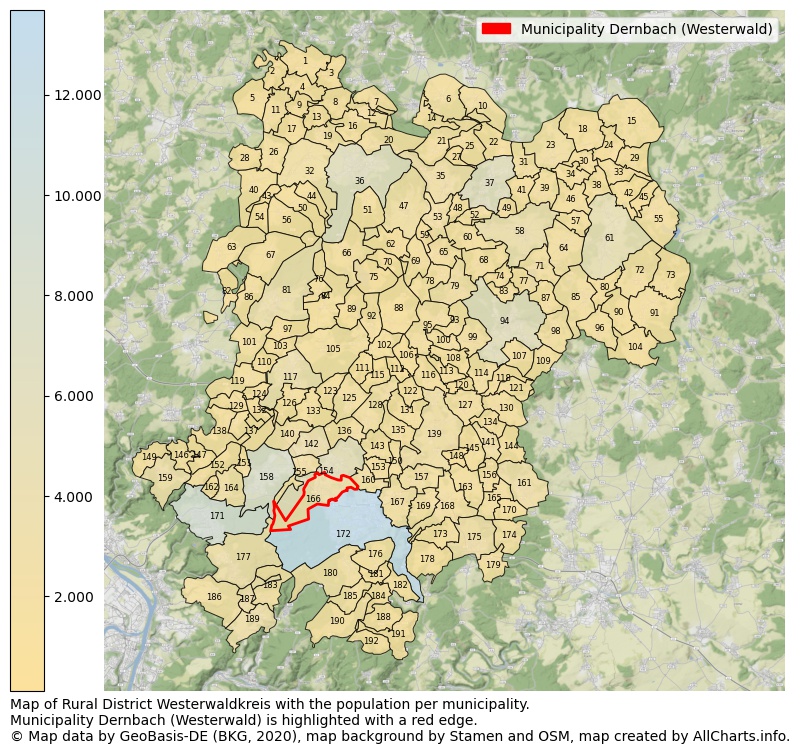
Map of Rural district Westerwaldkreis with the population per municipality.Municipality Dernbach (Westerwald) is highlighted with a red edge. The numbers at the map represent the following municipalities: 1: municipality Mörsbach, 2: municipality Stein-Wingert, 3: municipality Kundert, 4: municipality Heimborn, 5: municipality Giesenhausen ...Show more... Map of Rural district Westerwaldkreis with the population per municipality.Municipality Dernbach (Westerwald) is highlighted with a red edge. The numbers at the map represent the following municipalities: 1: municipality Mörsbach, 2: municipality Stein-Wingert, 3: municipality Kundert, 4: municipality Heimborn, 5: municipality Giesenhausen, 6: municipality Neunkhausen, 7: municipality Luckenbach, 8: municipality Limbach, 9: municipality Heuzert, 10: municipality Langenbach bei Kirburg, 11: municipality Kroppach, 12: municipality Atzelgift, 13: municipality Astert, 14: municipality Mörlen, 15: municipality Liebenscheid, 16: municipality Streithausen, 17: municipality Marzhausen, 18: municipality Stein-Neukirch, 19: municipality Müschenbach, 20: municipality Nister, 21: municipality Norken, 22: municipality Lautzenbrücken, 23: municipality Hof, 24: municipality Bretthausen, 25: municipality Kirburg, 26: municipality Mudenbach, 27: municipality Bölsberg, 28: municipality Borod, 29: municipality Willingen, 30: municipality Salzburg, 31: municipality Nisterau, 32: municipality Hattert, 33: municipality Nister-Möhrendorf, 34: municipality Oberroßbach, 35: municipality Unnau, 36: municipality city Hachenburg, 37: municipality city Bad Marienberg (Westerwald), 38: municipality Zehnhausen bei Rennerod, 39: municipality Fehl-Ritzhausen, 40: municipality Wahlrod, 41: municipality Stockhausen-Illfurth, 42: municipality Waigandshain, 43: municipality Winkelbach, 44: municipality Merkelbach, 45: municipality Homberg, 46: municipality Niederroßbach, 47: municipality Alpenrod, 48: municipality Hardt, 49: municipality Großseifen, 50: municipality Wied, 51: municipality Gehlert, 52: municipality Hahn bei Marienberg, 53: municipality Nistertal, 54: municipality Welkenbach, 55: municipality Rehe, 56: municipality Höchstenbach, 57: municipality Neustadt/Westerwald, 58: municipality Höhn, 59: municipality Enspel, 60: municipality Dreisbach, 61: municipality city Rennerod, 62: municipality Lochum, 63: municipality Roßbach, 64: municipality Hellenhahn-Schellenberg, 65: municipality Stockum-Püschen, 66: municipality Steinebach an der Wied, 67: municipality Mündersbach, 68: municipality Ailertchen, 69: municipality Rotenhain, 70: municipality Linden, 71: municipality Pottum, 72: municipality Westernohe, 73: municipality Oberrod, 74: municipality Halbs, 75: municipality Dreifelden, 76: municipality Schenkelberg, 77: municipality Stahlhofen am Wiesensee, 78: municipality Bellingen, 79: municipality Langenhahn, 80: municipality Waldmühlen, 81: municipality Herschbach, 82: municipality Maroth, 83: municipality Hergenroth, 84: municipality Hartenfels, 85: municipality Seck, 86: municipality Freirachdorf, 87: municipality Winnen, 88: municipality Wölferlingen, 89: municipality Steinen, 90: municipality Hüblingen, 91: municipality Elsoff (Westerwald), 92: municipality Freilingen, 93: municipality Brandscheid, 94: municipality city Westerburg, 95: municipality Rothenbach, 96: municipality Irmtraut, 97: municipality Rückeroth, 98: municipality Gemünden, 99: municipality Kölbingen, 100: municipality Kaden, 101: municipality Marienrachdorf, 102: municipality Weidenhahn, 103: municipality Goddert, 104: municipality Neunkirchen, 105: municipality Maxsain, 106: municipality Arnshöfen, 107: municipality Willmenrod, 108: municipality Härtlingen, 109: municipality Berzhahn, 110: municipality Krümmel, 111: municipality Ewighausen, 112: municipality Kuhnhöfen, 113: municipality Elbingen, 114: municipality Guckheim, 115: municipality Niedersayn, 116: municipality Hahn am See, 117: municipality city Selters (Westerwald), 118: municipality Weltersburg, 119: municipality Sessenhausen, 120: municipality Mähren, 121: municipality Girkenroth, 122: municipality Ettinghausen, 123: municipality Quirnbach, 124: municipality Ellenhausen, 125: municipality Helferskirchen, 126: municipality Nordhofen, 127: municipality Herschbach (Oberwesterwald), 128: municipality Ötzingen, 129: municipality Deesen, 130: municipality Salz, 131: municipality Oberahr, 132: municipality Oberhaid, 133: municipality Vielbach, 134: municipality Bilkheim, 135: municipality Niederahr, 136: municipality Leuterod, 137: municipality Wittgert, 138: municipality Breitenau, 139: municipality Meudt, 140: municipality Mogendorf, 141: municipality Wallmerod, 142: municipality Siershahn, 143: municipality Moschheim, 144: municipality Molsberg, 145: municipality Berod bei Wallmerod, 146: municipality Sessenbach, 147: municipality Wirscheid, 148: municipality Zehnhausen bei Wallmerod, 149: municipality Caan, 150: municipality Boden, 151: municipality Hundsdorf, 152: municipality Alsbach, 153: municipality Bannberscheid, 154: municipality city Wirges, 155: municipality Ebernhahn, 156: municipality Weroth, 157: municipality Ruppach-Goldhausen, 158: municipality city Ransbach-Baumbach, 159: municipality Nauort, 160: municipality Staudt, 161: municipality Hundsangen, 162: municipality Kammerforst, 163: municipality Steinefrenz, 164: municipality Hilgert, 165: municipality Dreikirchen, 166: municipality Dernbach (Westerwald), 167: municipality Heiligenroth, 168: municipality Girod, 169: municipality Großholbach, 170: municipality Obererbach, 171: municipality city Höhr-Grenzhausen, 172: municipality city Montabaur, 173: municipality Nomborn, 174: municipality Niedererbach, 175: municipality Nentershausen, 176: municipality Holler, 177: municipality Hillscheid, 178: municipality Heilberscheid, 179: municipality Görgeshausen, 180: municipality Niederelbert, 181: municipality Untershausen, 182: municipality Stahlhofen, 183: municipality Kadenbach, 184: municipality Daubach, 185: municipality Oberelbert, 186: municipality Simmern, 187: municipality Neuhäusel, 188: municipality Horbach, 189: municipality Eitelborn, 190: municipality Welschneudorf, 191: municipality Gackenbach, 192: municipality Hübingen ...Show less...
The number of rooms per house (dwelling)
The number of rooms of the houses in the municipality Dernbach (Westerwald)
One moment please, your device is loading the charts...
Municipality Dernbach (Westerwald), 2019, number of rooms per house.
The percentage shows the relative share of houses per category based on the numer of rooms: 1 to 2 rooms, 3 to 4 rooms or 5 rooms or more. This is based on the total number of rooms as identified for all dwellings in the municipality Dernbach (Westerwald).
Data about more than 100 topics!
The table below shows data for more than 100 topics as most recently available for the municipality Dernbach (Westerwald). Select a category to display the related topics:
| Business | Value | Unit | Year |
|---|---|---|---|
| Businesses | 1 | Number | 2017 |
| Active persons | 0 | Number | 2017 |
| Gross wages | €0 | Euro | 2017 |
| Dwellings | Value | Unit | Year |
|---|---|---|---|
| Houses 1 room | 8 | Number | 2019 |
| Houses 2 rooms | 55 | Number | 2019 |
| Houses 3 rooms | 126 | Number | 2019 |
| Houses 4 rooms | 224 | Number | 2019 |
| Houses 5 rooms | 202 | Number | 2019 |
| Houses 6 rooms | 222 | Number | 2019 |
| Houses 7+ rooms | 295 | Number | 2019 |
| Houses 1-2 rooms | 63 | Number | 2019 |
| Houses 3-4 rooms | 350 | Number | 2019 |
| Houses 5+ rooms | 719 | Number | 2019 |
| 1-2 rooms | 6% | Percentage | 2019 |
| 3-4 rooms | 31% | Percentage | 2019 |
| 5+ rooms | 64% | Percentage | 2019 |
| Elections | Value | Unit | Year |
|---|---|---|---|
| Voters Bundestag | 1936,00 | Number | 2017 |
| Voter turnout Bundestag | 67 | Number | 2017 |
| Votes valid Bundestag | 868 | Number | 2017 |
| Votes Bundestag CDU/CSU | 381 | Number | 2017 |
| Votes Bundestag SPD | 176 | Number | 2017 |
| Votes Bundestag GRÜNE | 51 | Number | 2017 |
| Votes Bundestag FDP | 95 | Number | 2017 |
| Votes Bundestag DIE LINKE | 53 | Number | 2017 |
| Votes Bundestag AfD | 84 | Number | 2017 |
| Votes Bundestag other parties | 28 | Number | 2017 |
| Votes Bundestag total | 868 | Number | 2017 |
| % Votes Bundestag CDU/CSU | 20% | Percentage | 2017 |
| % Votes Bundestag SPD | 9% | Percentage | 2017 |
| % Votes Bundestag GRÜNE | 3% | Percentage | 2017 |
| % Votes Bundestag FDP | 5% | Percentage | 2017 |
| % Votes Bundestag DIE LINKE | 3% | Percentage | 2017 |
| % Votes Bundestag AfD | 4% | Percentage | 2017 |
| % Votes Bundestag other parties | 1% | Percentage | 2017 |
| Employment | Value | Unit | Year |
|---|---|---|---|
| Employees | 935 | Number | 2019 |
| Employees male | 518 | Number | 2019 |
| Employees female | 417 | Number | 2019 |
| Employees foreigner | 89 | Number | 2019 |
| Employees male foreigner | 59 | Number | 2019 |
| Employees female foreigner | 30 | Number | 2019 |
| Unemployed | 26 | Number | 2018 |
| Unemployed foreigners | 9 | Number | 2018 |
| Unemployed severely disabled | 1 | Number | 2018 |
| Unemployed 15-20 | 1 | Number | 2018 |
| Unemployed 15-25 | 3 | Number | 2018 |
| Unemployed 55-65 | 7 | Number | 2018 |
| Unemployed long-term | 5 | Number | 2018 |
| % Unemployed | 1% | Percentage | 2018 |
| % Unemployed foreigners | 0% | Percentage of the population | 2018 |
| % Unemployed severely disabled | 0% | Percentage of the population | 2018 |
| % Unemployed 15-20 | 0% | Percentage of the population | 2018 |
| % Unemployed 15-25 | 0% | Percentage of the population | 2018 |
| % Unemployed 55-65 | 0% | Percentage of the population | 2018 |
| % Unemployed long-term | 0% | Percentage of the population | 2018 |
| Income | Value | Unit | Year |
|---|---|---|---|
| Income receivers | 1.084 | Number | 2015 |
| Income total | €39.256 | Euro | 2015 |
| Income tax | €6.175 | Euro | 2015 |
| Population | Value | Unit | Year |
|---|---|---|---|
| Population | 2.504 | Number | 2019 |
| Men | 1.167 | Number | 2019 |
| Women | 1.337 | Number | 2019 |
| % Men | 47% | Percentage | 2019 |
| % Women | 53% | Percentage | 2019 |
| 0-18 | 336 | Number | 2019 |
| 18-30 | 303 | Number | 2019 |
| 30-45 | 365 | Number | 2019 |
| 45-60 | 582 | Number | 2019 |
| 18-60 | 1.250 | Number | 2019 |
| 60-75 | 423 | Number | 2019 |
| 60+ | 918 | Number | 2019 |
| Average age | 50 | Average number | 2019 |
| Average age male | 46 | Average number | 2019 |
| Average age female | 53 | Average number | 2019 |
| Births | 12 | Number | 2018 |
| Births male | 6 | Number | 2018 |
| Births female | 6 | Number | 2018 |
| 1K Births | 5 | Number per 1000 inhabitants | 2018 |
| Deaths | 58 | Number | 2018 |
| Deaths male | 19 | Number | 2018 |
| Deaths female | 39 | Number | 2018 |
| 1K Deaths | 23 | Number | 2018 |
| 0-3 | 54 | Number | 2019 |
| Girls 0-3 | 24 | Number | 2019 |
| Boys 0-3 | 30 | Number | 2019 |
| 3-6 | 52 | Number | 2019 |
| Girls 3-6 | 26 | Number | 2019 |
| Boys 3-6 | 26 | Number | 2019 |
| 6-10 | 72 | Number | 2019 |
| 10-15 | 91 | Number | 2019 |
| 15-18 | 67 | Number | 2019 |
| 18-20 | 47 | Number | 2019 |
| 20-25 | 118 | Number | 2019 |
| 25-30 | 138 | Number | 2019 |
| 30-35 | 131 | Number | 2019 |
| 35-40 | 116 | Number | 2019 |
| 40-45 | 118 | Number | 2019 |
| 45-50 | 157 | Number | 2019 |
| 50-55 | 217 | Number | 2019 |
| 55-60 | 208 | Number | 2019 |
| 60-65 | 155 | Number | 2019 |
| 65-75 | 268 | Number | 2019 |
| Women 65-70 | 154 | Number | 2019 |
| Men 65-70 | 114 | Number | 2019 |
| 75+ | 495 | Number | 2019 |
| Women 75+ | 344 | Number | 2019 |
| Men 75+ | 151 | Number | 2019 |
| % 0-10 | 7% | Percentage | 2019 |
| % 10-18 | 6% | Percentage | 2019 |
| % 18-30 | 12% | Percentage | 2019 |
| % 30-45 | 15% | Percentage | 2019 |
| % 45-60 | 23% | Percentage | 2019 |
| % 60+ | 37% | Percentage | 2019 |
| Real estate | Value | Unit | Year |
|---|---|---|---|
| Property tax A revenue | €4.054 | Euro | 2018 |
| Property tax B revenue | €284.407 | Euro | 2018 |
| Trade tax actual revenue | €535.853 | Euro | 2018 |
| Property tax A basic amount | €1.351 | Euro | 2018 |
| Property tax B basic amount | €77.920 | Euro | 2018 |
| Trade tax basic amount | €146.809 | Euro | 2018 |
| Property tax A rate | €300 | Euro | 2018 |
| Property tax B rate | €365 | Euro | 2018 |
| Trade tax rate | €365 | Euro | 2018 |
| Real tax raising force | €962.879 | Euro | 2018 |
| Trade tax levy | €100.271 | Euro | 2018 |
| Trade tax net | €435.582 | Euro | 2018 |
| Community share in income tax | €989.207 | Euro | 2018 |
| Community share in sales tax | €318.789 | Euro | 2018 |
| Tax revenue | €2.170.604 | Euro | 2018 |
| Regional | Value | Unit | Year |
|---|---|---|---|
| Region code | 071435010010 | Code | 2019 |
| Region code 8 digits | 07143010 | Code | 07143010 |
| Sorting code | 071435010010 | Code | 071435010010 |
| Sorting code 8 digits | 07143010 | Code | 07143010 |
| Region name | Dernbach (Westerwald) | Name | 2019 |
| Regional level | 6 | Categorical type | 2019 |
| Region type | Municipality | Categorical type | 2019 |
| Region type detail | municipality | Categorical type | 2019 |
| Region name with type | municipality Dernbach (Westerwald) | Name | 2019 |
| Region name in German | Gemeinde Dernbach (Westerwald) | Name | 2019 |
| Direct subregions | no data | Number | 2019 |
| NUTS code | DEB1B | Code | 2019 |
| Area | 9 | Area in km² | 2019 |
| Religion | Value | Unit | Year |
|---|---|---|---|
| Roman Catholic church | 1.750 | Number | 2011 |
| Protestant church | 283 | Number | 2011 |
| Other or none | 377 | Number | 2011 |
| % Roman Catholic church | 73% | Percentage | 2011 |
| % Protestant church | 12% | Percentage | 2011 |
| % Other or none | 16% | Percentage | 2011 |
| Roman Catholic church German | 1.689 | Number | 2011 |
| Protestant church German | 283 | Number | 2011 |
| Other or none German | 289 | Number | 2011 |
| % Roman Catholic church German | 75% | Percentage | 2011 |
| % Protestant church German | 13% | Percentage | 2011 |
| % Other or none German Foreign | 13% | Percentage | 2011 |
| Roman Catholic church Foreign | 61 | Number | 2011 |
| Protestant church Foreign | 0 | Number | 2011 |
| Other or none Foreign | 88 | Number | 2011 |
| % Roman Catholic church Foreign | 41% | Percentage | 2011 |
| % Protestant church Foreign | 0% | Percentage | 2011 |
| % Other or none Foreign | 59% | Percentage | 2011 |
Open data sources used
Data is used from multiple German open data providers. See this description of the sources with the definitions of all regional topics.
Sources & definitionsUnder development
Work is in progress to add more information to this page
This page will be further expanded with more topics in clear graphs. This will be done in several iterations in the coming weeks.