Population numbers per year
The number of inhabitants in the municipality Elmenhorst
One moment please, your device is loading the charts...
Population numbers in the municipality Elmenhorst for the years 2009 thru 2019.
The number of inhabitants is the number of persons as registered in the population register on January 1st.
Population at the map of Elmenhorst
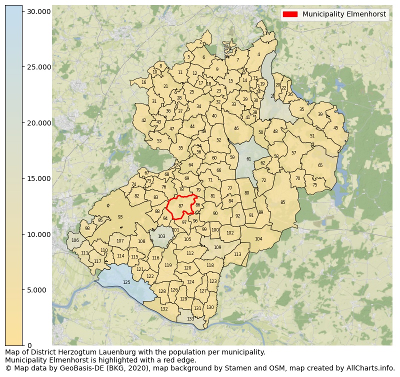
Map of District Herzogtum Lauenburg with the population per municipality.Municipality Elmenhorst is highlighted with a red edge. The numbers at the map represent the following municipalities: 1: municipality Groß Grönau, 2: municipality Groß Schenkenberg, 3: municipality Krummesse, 4: municipality Groß Sarau, 5: municipality Grinau ...Show more... Map of District Herzogtum Lauenburg with the population per municipality.Municipality Elmenhorst is highlighted with a red edge. The numbers at the map represent the following municipalities: 1: municipality Groß Grönau, 2: municipality Groß Schenkenberg, 3: municipality Krummesse, 4: municipality Groß Sarau, 5: municipality Grinau, 6: municipality Bliestorf, 7: municipality Klempau, 8: municipality Schürensöhlen, 9: municipality Rondeshagen, 10: municipality Groß Boden, 11: municipality Siebenbäumen, 12: municipality Kastorf, 13: municipality Pogeez, 14: municipality Groß Disnack, 15: municipality Berkenthin, 16: municipality Stubben, 17: municipality Düchelsdorf, 18: municipality Sierksrade, 19: municipality Buchholz, 20: municipality Römnitz, 21: municipality Steinhorst, 22: municipality Bäk, 23: municipality Göldenitz, 24: municipality Einhaus, 25: municipality Klinkrade, 26: municipality Mechow, 27: municipality city Ratzeburg, 28: municipality Labenz, 29: municipality Kulpin, 30: municipality Harmsdorf, 31: municipality Schiphorst, 32: municipality Niendorf bei Berkenthin, 33: municipality Behlendorf, 34: municipality Duvensee, 35: municipality Ziethen, 36: municipality Sandesneben, 37: municipality Lüchow, 38: municipality Giesensdorf, 39: municipality Mustin, 40: municipality Kühsen, 41: municipality Albsfelde, 42: municipality Schönberg, 43: municipality Wentorf (Amt Sandesneben), 44: municipality Ritzerau, 45: municipality Kittlitz, 46: municipality Lankau, 47: municipality Sirksfelde, 48: municipality Schmilau, 49: municipality Nusse, 50: municipality Fredeburg, 51: municipality Salem, 52: municipality Panten, 53: municipality Linau, 54: municipality Poggensee, 55: municipality Koberg, 56: municipality Walksfelde, 57: municipality Sterley, 58: municipality Horst, 59: municipality Alt Mölln, 60: municipality Bälau, 61: municipality city Mölln, 62: municipality Brunsmark, 63: municipality Köthel, 64: municipality Borstorf, 65: municipality Seedorf, 66: municipality Breitenfelde, 67: municipality Hamfelde, 68: municipality Mühlenrade, 69: municipality Schretstaken, 70: municipality Hollenbek, 71: municipality Niendorf/Stecknitz, 72: municipality Lehmrade, 73: municipality Dahmker, 74: municipality Kuddewörde, 75: municipality Klein Zecher, 76: municipality Basthorst, 77: municipality Woltersdorf, 78: municipality Fuhlenhagen, 79: municipality Talkau, 80: municipality Grambek, 81: municipality Tramm, 82: municipality Kasseburg, 83: municipality Möhnsen, 84: municipality Hornbek, 85: municipality Gudow, 86: municipality Kankelau, 87: municipality Elmenhorst, 88: municipality Havekost, 89: municipality Besenthal, 90: municipality Roseburg, 91: municipality Göttin, 92: municipality Güster, 93: unincorporated area Sachsenwald (Forstgutsbez.), 94: municipality Grove, 95: municipality Aumühle, 96: municipality Groß Pampau, 97: municipality Sahms, 98: municipality Wohltorf, 99: municipality Klein Pampau, 100: municipality Siebeneichen, 101: municipality Grabau, 102: municipality Fitzen, 103: municipality city Schwarzenbek, 104: municipality Langenlehsten, 105: municipality Müssen, 106: municipality Wentorf bei Hamburg, 107: municipality Dassendorf, 108: municipality Brunstorf, 109: municipality Büchen, 110: municipality Kröppelshagen-Fahrendorf, 111: municipality Börnsen, 112: municipality Schulendorf, 113: municipality Bröthen, 114: municipality Hohenhorn, 115: municipality Worth, 116: municipality Kollow, 117: municipality Escheburg, 118: municipality Witzeeze, 119: municipality Gülzow, 120: municipality Wangelau, 121: municipality Hamwarde, 122: municipality Wiershop, 123: municipality Dalldorf, 124: municipality Lütau, 125: municipality city Geesthacht, 126: municipality Juliusburg, 127: municipality Basedow, 128: municipality Krukow, 129: municipality Krüzen, 130: municipality Lanze, 131: municipality Buchhorst, 132: municipality Schnakenbek, 133: municipality city Lauenburg/Elbe ...Show less...
The number of rooms per house (dwelling)
The number of rooms of the houses in the municipality Elmenhorst
One moment please, your device is loading the charts...
Municipality Elmenhorst, 2019, number of rooms per house.
The percentage shows the relative share of houses per category based on the numer of rooms: 1 to 2 rooms, 3 to 4 rooms or 5 rooms or more. This is based on the total number of rooms as identified for all dwellings in the municipality Elmenhorst.
Data about more than 100 topics!
The table below shows data for more than 100 topics as most recently available for the municipality Elmenhorst. Select a category to display the related topics:
| Business | Value | Unit | Year |
|---|---|---|---|
| Businesses | 2 | Number | 2017 |
| Active persons | 0 | Number | 2017 |
| Gross wages | €0 | Euro | 2017 |
| Dwellings | Value | Unit | Year |
|---|---|---|---|
| Houses 1 room | 6 | Number | 2019 |
| Houses 2 rooms | 14 | Number | 2019 |
| Houses 3 rooms | 57 | Number | 2019 |
| Houses 4 rooms | 87 | Number | 2019 |
| Houses 5 rooms | 74 | Number | 2019 |
| Houses 6 rooms | 69 | Number | 2019 |
| Houses 7+ rooms | 87 | Number | 2019 |
| Houses 1-2 rooms | 20 | Number | 2019 |
| Houses 3-4 rooms | 144 | Number | 2019 |
| Houses 5+ rooms | 230 | Number | 2019 |
| 1-2 rooms | 5% | Percentage | 2019 |
| 3-4 rooms | 37% | Percentage | 2019 |
| 5+ rooms | 58% | Percentage | 2019 |
| Elections | Value | Unit | Year |
|---|---|---|---|
| Voters Bundestag | 638,00 | Number | 2017 |
| Voter turnout Bundestag | 68 | Number | 2017 |
| Votes valid Bundestag | 433 | Number | 2017 |
| Votes Bundestag CDU/CSU | 158 | Number | 2017 |
| Votes Bundestag SPD | 93 | Number | 2017 |
| Votes Bundestag GRÜNE | 43 | Number | 2017 |
| Votes Bundestag FDP | 51 | Number | 2017 |
| Votes Bundestag DIE LINKE | 22 | Number | 2017 |
| Votes Bundestag AfD | 56 | Number | 2017 |
| Votes Bundestag other parties | 10 | Number | 2017 |
| Votes Bundestag total | 433 | Number | 2017 |
| % Votes Bundestag CDU/CSU | 25% | Percentage | 2017 |
| % Votes Bundestag SPD | 15% | Percentage | 2017 |
| % Votes Bundestag GRÜNE | 7% | Percentage | 2017 |
| % Votes Bundestag FDP | 8% | Percentage | 2017 |
| % Votes Bundestag DIE LINKE | 3% | Percentage | 2017 |
| % Votes Bundestag AfD | 9% | Percentage | 2017 |
| % Votes Bundestag other parties | 2% | Percentage | 2017 |
| Employment | Value | Unit | Year |
|---|---|---|---|
| Employees | 381 | Number | 2019 |
| Employees male | 205 | Number | 2019 |
| Employees female | 176 | Number | 2019 |
| Employees foreigner | 27 | Number | 2019 |
| Employees male foreigner | 17 | Number | 2019 |
| Employees female foreigner | 10 | Number | 2019 |
| Unemployed | 16 | Number | 2018 |
| Unemployed foreigners | 2 | Number | 2018 |
| Unemployed severely disabled | 1 | Number | 2018 |
| Unemployed 15-20 | 0 | Number | 2018 |
| Unemployed 15-25 | 4 | Number | 2018 |
| Unemployed 55-65 | 6 | Number | 2018 |
| Unemployed long-term | 5 | Number | 2018 |
| % Unemployed | 2% | Percentage | 2018 |
| % Unemployed foreigners | 0% | Percentage of the population | 2018 |
| % Unemployed severely disabled | 0% | Percentage of the population | 2018 |
| % Unemployed 15-20 | 0% | Percentage of the population | 2018 |
| % Unemployed 15-25 | 0% | Percentage of the population | 2018 |
| % Unemployed 55-65 | 1% | Percentage of the population | 2018 |
| % Unemployed long-term | 1% | Percentage of the population | 2018 |
| Income | Value | Unit | Year |
|---|---|---|---|
| Income receivers | 427 | Number | 2015 |
| Income total | €17.172 | Euro | 2015 |
| Income tax | €2.903 | Euro | 2015 |
| Population | Value | Unit | Year |
|---|---|---|---|
| Population | 897 | Number | 2019 |
| Men | 476 | Number | 2019 |
| Women | 421 | Number | 2019 |
| % Men | 53% | Percentage | 2019 |
| % Women | 47% | Percentage | 2019 |
| 0-18 | 159 | Number | 2019 |
| 18-30 | 161 | Number | 2019 |
| 30-45 | 161 | Number | 2019 |
| 45-60 | 241 | Number | 2019 |
| 18-60 | 563 | Number | 2019 |
| 60-75 | 110 | Number | 2019 |
| 60+ | 175 | Number | 2019 |
| Average age | 41 | Average number | 2019 |
| Average age male | 40 | Average number | 2019 |
| Average age female | 41 | Average number | 2019 |
| Births | 8 | Number | 2018 |
| Births male | 4 | Number | 2018 |
| Births female | 4 | Number | 2018 |
| 1K Births | 9 | Number per 1000 inhabitants | 2018 |
| Deaths | 7 | Number | 2018 |
| Deaths male | 5 | Number | 2018 |
| Deaths female | 2 | Number | 2018 |
| 1K Deaths | 8 | Number | 2018 |
| 0-3 | 32 | Number | 2019 |
| Girls 0-3 | 13 | Number | 2019 |
| Boys 0-3 | 19 | Number | 2019 |
| 3-6 | 23 | Number | 2019 |
| Girls 3-6 | 8 | Number | 2019 |
| Boys 3-6 | 15 | Number | 2019 |
| 6-10 | 30 | Number | 2019 |
| 10-15 | 45 | Number | 2019 |
| 15-18 | 29 | Number | 2019 |
| 18-20 | 24 | Number | 2019 |
| 20-25 | 69 | Number | 2019 |
| 25-30 | 68 | Number | 2019 |
| 30-35 | 62 | Number | 2019 |
| 35-40 | 61 | Number | 2019 |
| 40-45 | 38 | Number | 2019 |
| 45-50 | 58 | Number | 2019 |
| 50-55 | 111 | Number | 2019 |
| 55-60 | 72 | Number | 2019 |
| 60-65 | 44 | Number | 2019 |
| 65-75 | 66 | Number | 2019 |
| Women 65-70 | 33 | Number | 2019 |
| Men 65-70 | 33 | Number | 2019 |
| 75+ | 65 | Number | 2019 |
| Women 75+ | 31 | Number | 2019 |
| Men 75+ | 34 | Number | 2019 |
| % 0-10 | 9% | Percentage | 2019 |
| % 10-18 | 8% | Percentage | 2019 |
| % 18-30 | 18% | Percentage | 2019 |
| % 30-45 | 18% | Percentage | 2019 |
| % 45-60 | 27% | Percentage | 2019 |
| % 60+ | 20% | Percentage | 2019 |
| Real estate | Value | Unit | Year |
|---|---|---|---|
| Property tax A revenue | €6.418 | Euro | 2018 |
| Property tax B revenue | €147.883 | Euro | 2018 |
| Trade tax actual revenue | €1.239.224 | Euro | 2018 |
| Property tax A basic amount | €2.731 | Euro | 2018 |
| Property tax B basic amount | €60.360 | Euro | 2018 |
| Trade tax basic amount | €442.580 | Euro | 2018 |
| Property tax A rate | €235 | Euro | 2018 |
| Property tax B rate | €245 | Euro | 2018 |
| Trade tax rate | €280 | Euro | 2018 |
| Real tax raising force | €2.073.797 | Euro | 2018 |
| Trade tax levy | €302.279 | Euro | 2018 |
| Trade tax net | €936.945 | Euro | 2018 |
| Community share in income tax | €437.537 | Euro | 2018 |
| Community share in sales tax | €137.236 | Euro | 2018 |
| Tax revenue | €2.346.291 | Euro | 2018 |
| Regional | Value | Unit | Year |
|---|---|---|---|
| Region code | 010535373027 | Code | 2019 |
| Region code 8 digits | 01053027 | Code | 01053027 |
| Sorting code | 010535373027 | Code | 010535373027 |
| Sorting code 8 digits | 01053027 | Code | 01053027 |
| Region name | Elmenhorst | Name | 2019 |
| Regional level | 6 | Categorical type | 2019 |
| Region type | Municipality | Categorical type | 2019 |
| Region type detail | municipality | Categorical type | 2019 |
| Region name with type | municipality Elmenhorst | Name | 2019 |
| Region name in German | Gemeinde Elmenhorst | Name | 2019 |
| Direct subregions | no data | Number | 2019 |
| NUTS code | DEF06 | Code | 2019 |
| Area | 13 | Area in km² | 2019 |
| Religion | Value | Unit | Year |
|---|---|---|---|
| Roman Catholic church | 42 | Number | 2011 |
| Protestant church | 400 | Number | 2011 |
| Other or none | 436 | Number | 2011 |
| % Roman Catholic church | 5% | Percentage | 2011 |
| % Protestant church | 45% | Percentage | 2011 |
| % Other or none | 50% | Percentage | 2011 |
| Roman Catholic church German | 33 | Number | 2011 |
| Protestant church German | 400 | Number | 2011 |
| Other or none German | 409 | Number | 2011 |
| % Roman Catholic church German | 4% | Percentage | 2011 |
| % Protestant church German | 48% | Percentage | 2011 |
| % Other or none German Foreign | 49% | Percentage | 2011 |
| Roman Catholic church Foreign | 9 | Number | 2011 |
| Protestant church Foreign | 0 | Number | 2011 |
| Other or none Foreign | 27 | Number | 2011 |
| % Roman Catholic church Foreign | 25% | Percentage | 2011 |
| % Protestant church Foreign | 0% | Percentage | 2011 |
| % Other or none Foreign | 75% | Percentage | 2011 |
Open data sources used
Data is used from multiple German open data providers. See this description of the sources with the definitions of all regional topics.
Sources & definitionsUnder development
Work is in progress to add more information to this page
This page will be further expanded with more topics in clear graphs. This will be done in several iterations in the coming weeks.