Population numbers per year
The number of inhabitants in the municipality Hamweddel
One moment please, your device is loading the charts...
Population numbers in the municipality Hamweddel for the years 2009 thru 2019.
The number of inhabitants is the number of persons as registered in the population register on January 1st.
Population at the map of Hamweddel
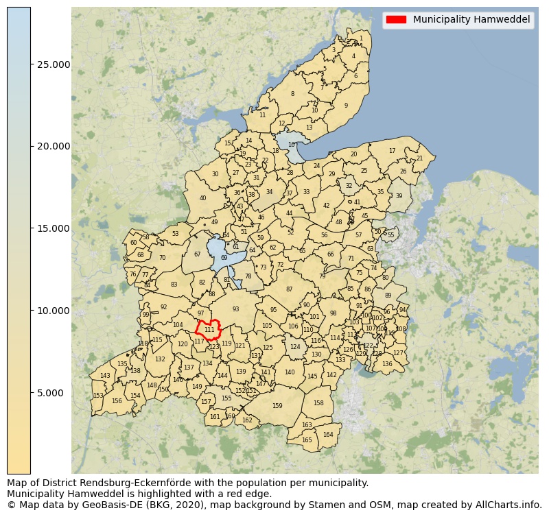
Map of District Rendsburg-Eckernförde with the population per municipality.Municipality Hamweddel is highlighted with a red edge. The numbers at the map represent the following municipalities: 1: municipality Brodersby, 2: municipality Karby, 3: municipality Winnemark, 4: municipality Dörphof, 5: municipality Thumby ...Show more... Map of District Rendsburg-Eckernförde with the population per municipality.Municipality Hamweddel is highlighted with a red edge. The numbers at the map represent the following municipalities: 1: municipality Brodersby, 2: municipality Karby, 3: municipality Winnemark, 4: municipality Dörphof, 5: municipality Thumby, 6: municipality Damp, 7: municipality Holzdorf, 8: municipality Rieseby, 9: municipality Waabs, 10: municipality Loose, 11: municipality Kosel, 12: municipality Gammelby, 13: municipality Barkelsby, 14: municipality Fleckeby, 15: municipality Güby, 16: municipality city Eckernförde, 17: municipality Schwedeneck, 18: municipality Windeby, 19: municipality Hummelfeld, 20: municipality Noer, 21: municipality Strande, 22: municipality Osterby, 23: municipality Hütten, 24: municipality Altenhof, 25: municipality Osdorf, 26: municipality Dänischenhagen, 27: municipality Ascheffel, 28: municipality Goosefeld, 29: municipality Neudorf-Bornstein, 30: municipality Brekendorf, 31: municipality Damendorf, 32: municipality Gettorf, 33: municipality Holtsee, 34: municipality Groß Wittensee, 35: municipality Felm, 36: municipality Ahlefeld-Bistensee, 37: municipality Haby, 38: municipality Klein Wittensee, 39: municipality Altenholz, 40: municipality Owschlag, 41: municipality Tüttendorf, 42: municipality Lindau, 43: municipality Holzbunge, 44: municipality Sehestedt, 45: municipality Neuwittenbek, 46: municipality Bünsdorf, 47: municipality Neu Duvenstedt, 48: municipality Schinkel, 49: municipality Alt Duvenstedt, 50: municipality Ottendorf, 51: municipality Borgstedt, 52: municipality Bovenau, 53: municipality Lohe-Föhrden, 54: municipality Rickert, 55: municipality Kronshagen, 56: municipality Krummwisch, 57: municipality Quarnbek, 58: municipality Königshügel, 59: municipality Rade b. Rendsburg, 60: municipality Christiansholm, 61: municipality city Büdelsdorf, 62: municipality Ostenfeld (Rendsburg), 63: municipality Melsdorf, 64: municipality Schacht-Audorf, 65: municipality Bredenbek, 66: municipality Felde, 67: municipality Fockbek, 68: municipality Friedrichsholm, 69: municipality city Rendsburg, 70: municipality Hohn, 71: municipality Achterwehr, 72: municipality Haßmoor, 73: municipality Schülldorf, 74: municipality Mielkendorf, 75: municipality Rodenbek, 76: municipality Friedrichsgraben, 77: municipality Sophienhamm, 78: municipality Osterrönfeld, 79: municipality Westensee, 80: municipality Molfsee, 81: municipality Westerrönfeld, 82: municipality Nübbel, 83: municipality Elsdorf-Westermühlen, 84: municipality Bargstall, 85: municipality Schierensee, 86: municipality Rumohr, 87: municipality Emkendorf, 88: municipality Schülp b. Rendsburg, 89: municipality Flintbek, 90: municipality Groß Vollstedt, 91: municipality Blumenthal, 92: municipality Hamdorf, 93: municipality Jevenstedt, 94: municipality Schönhorst, 95: municipality Bokel, 96: municipality Böhnhusen, 97: municipality Hörsten, 98: municipality Langwedel, 99: municipality Prinzenmoor, 100: municipality Grevenkrug, 101: municipality Warder, 102: municipality Techelsdorf, 103: municipality Sören, 104: municipality Breiholz, 105: municipality Brammer, 106: municipality Ellerdorf, 107: municipality Schmalstede, 108: municipality Bissee, 109: municipality Reesdorf, 110: municipality Eisendorf, 111: municipality Hamweddel, 112: municipality Brügge, 113: municipality Hoffeld, 114: municipality Dätgen, 115: municipality Tackesdorf, 116: municipality Borgdorf-Seedorf, 117: municipality Embühren, 118: municipality Oldenbüttel, 119: municipality Stafstedt, 120: municipality Haale, 121: municipality Luhnstedt, 122: municipality Bordesholm, 123: municipality Brinjahe, 124: municipality city Nortorf, 125: municipality Bargstedt, 126: municipality Schönbek, 127: municipality Groß Buchwald, 128: municipality Wattenbek, 129: municipality Mühbrook, 130: municipality Schülp b. Nortorf, 131: municipality Oldenhütten, 132: municipality Lütjenwestedt, 133: municipality Loop, 134: municipality Nienborstel, 135: municipality Steenfeld, 136: municipality Negenharrie, 137: municipality Todenbüttel, 138: municipality Hanerau-Hademarschen, 139: municipality Nindorf, 140: municipality Gnutz, 141: municipality Heinkenborstel, 142: municipality Krogaspe, 143: municipality Beldorf, 144: municipality Remmels, 145: municipality Timmaspe, 146: municipality Beringstedt, 147: municipality Mörel, 148: municipality Gokels, 149: municipality Osterstedt, 150: municipality Seefeld, 151: municipality Rade b. Hohenwestedt, 152: municipality Tappendorf, 153: municipality Bornholt, 154: municipality Thaden, 155: municipality Hohenwestedt, 156: municipality Bendorf, 157: municipality Wapelfeld, 158: municipality Wasbek, 159: municipality Aukrug, 160: municipality Grauel, 161: municipality Jahrsdorf, 162: municipality Meezen, 163: municipality Ehndorf, 164: municipality Padenstedt, 165: municipality Arpsdorf ...Show less...
The number of rooms per house (dwelling)
The number of rooms of the houses in the municipality Hamweddel
One moment please, your device is loading the charts...
Municipality Hamweddel, 2019, number of rooms per house.
The percentage shows the relative share of houses per category based on the numer of rooms: 1 to 2 rooms, 3 to 4 rooms or 5 rooms or more. This is based on the total number of rooms as identified for all dwellings in the municipality Hamweddel.
Data about more than 100 topics!
The table below shows data for more than 100 topics as most recently available for the municipality Hamweddel. Select a category to display the related topics:
| Business | Value | Unit | Year |
|---|---|---|---|
| Businesses | no data | Number | 2015 |
| Active persons | no data | Number | 2015 |
| Gross wages | no data | Euro | 2015 |
| Dwellings | Value | Unit | Year |
|---|---|---|---|
| Houses 1 room | 1 | Number | 2019 |
| Houses 2 rooms | 5 | Number | 2019 |
| Houses 3 rooms | 21 | Number | 2019 |
| Houses 4 rooms | 44 | Number | 2019 |
| Houses 5 rooms | 45 | Number | 2019 |
| Houses 6 rooms | 39 | Number | 2019 |
| Houses 7+ rooms | 51 | Number | 2019 |
| Houses 1-2 rooms | 6 | Number | 2019 |
| Houses 3-4 rooms | 65 | Number | 2019 |
| Houses 5+ rooms | 135 | Number | 2019 |
| 1-2 rooms | 3% | Percentage | 2019 |
| 3-4 rooms | 32% | Percentage | 2019 |
| 5+ rooms | 66% | Percentage | 2019 |
| Elections | Value | Unit | Year |
|---|---|---|---|
| Voters Bundestag | 371,00 | Number | 2017 |
| Voter turnout Bundestag | 65 | Number | 2017 |
| Votes valid Bundestag | 237 | Number | 2017 |
| Votes Bundestag CDU/CSU | 99 | Number | 2017 |
| Votes Bundestag SPD | 64 | Number | 2017 |
| Votes Bundestag GRÜNE | 24 | Number | 2017 |
| Votes Bundestag FDP | 15 | Number | 2017 |
| Votes Bundestag DIE LINKE | 9 | Number | 2017 |
| Votes Bundestag AfD | 22 | Number | 2017 |
| Votes Bundestag other parties | 4 | Number | 2017 |
| Votes Bundestag total | 237 | Number | 2017 |
| % Votes Bundestag CDU/CSU | 27% | Percentage | 2017 |
| % Votes Bundestag SPD | 17% | Percentage | 2017 |
| % Votes Bundestag GRÜNE | 6% | Percentage | 2017 |
| % Votes Bundestag FDP | 4% | Percentage | 2017 |
| % Votes Bundestag DIE LINKE | 2% | Percentage | 2017 |
| % Votes Bundestag AfD | 6% | Percentage | 2017 |
| % Votes Bundestag other parties | 1% | Percentage | 2017 |
| Employment | Value | Unit | Year |
|---|---|---|---|
| Employees | 189 | Number | 2019 |
| Employees male | 110 | Number | 2019 |
| Employees female | 79 | Number | 2019 |
| Employees foreigner | 6 | Number | 2019 |
| Employees male foreigner | 0 | Number | 2019 |
| Employees female foreigner | 0 | Number | 2019 |
| Unemployed | 6 | Number | 2018 |
| Unemployed foreigners | 0 | Number | 2018 |
| Unemployed severely disabled | 0 | Number | 2018 |
| Unemployed 15-20 | 0 | Number | 2018 |
| Unemployed 15-25 | 1 | Number | 2018 |
| Unemployed 55-65 | 1 | Number | 2018 |
| Unemployed long-term | 1 | Number | 2018 |
| % Unemployed | 1% | Percentage | 2018 |
| % Unemployed foreigners | 0% | Percentage of the population | 2018 |
| % Unemployed severely disabled | 0% | Percentage of the population | 2018 |
| % Unemployed 15-20 | 0% | Percentage of the population | 2018 |
| % Unemployed 15-25 | 0% | Percentage of the population | 2018 |
| % Unemployed 55-65 | 0% | Percentage of the population | 2018 |
| % Unemployed long-term | 0% | Percentage of the population | 2018 |
| Income | Value | Unit | Year |
|---|---|---|---|
| Income receivers | 207 | Number | 2015 |
| Income total | €7.105 | Euro | 2015 |
| Income tax | €981 | Euro | 2015 |
| Population | Value | Unit | Year |
|---|---|---|---|
| Population | 450 | Number | 2019 |
| Men | 232 | Number | 2019 |
| Women | 218 | Number | 2019 |
| % Men | 52% | Percentage | 2019 |
| % Women | 48% | Percentage | 2019 |
| 0-18 | 86 | Number | 2019 |
| 18-30 | 65 | Number | 2019 |
| 30-45 | 68 | Number | 2019 |
| 45-60 | 119 | Number | 2019 |
| 18-60 | 252 | Number | 2019 |
| 60-75 | 72 | Number | 2019 |
| 60+ | 112 | Number | 2019 |
| Average age | 43 | Average number | 2019 |
| Average age male | 44 | Average number | 2019 |
| Average age female | 43 | Average number | 2019 |
| Births | 4 | Number | 2018 |
| Births male | 3 | Number | 2018 |
| Births female | 1 | Number | 2018 |
| 1K Births | 9 | Number per 1000 inhabitants | 2018 |
| Deaths | 5 | Number | 2018 |
| Deaths male | 3 | Number | 2018 |
| Deaths female | 2 | Number | 2018 |
| 1K Deaths | 11 | Number | 2018 |
| 0-3 | 11 | Number | 2019 |
| Girls 0-3 | 5 | Number | 2019 |
| Boys 0-3 | 6 | Number | 2019 |
| 3-6 | 12 | Number | 2019 |
| Girls 3-6 | 8 | Number | 2019 |
| Boys 3-6 | 4 | Number | 2019 |
| 6-10 | 16 | Number | 2019 |
| 10-15 | 24 | Number | 2019 |
| 15-18 | 23 | Number | 2019 |
| 18-20 | 9 | Number | 2019 |
| 20-25 | 22 | Number | 2019 |
| 25-30 | 34 | Number | 2019 |
| 30-35 | 23 | Number | 2019 |
| 35-40 | 28 | Number | 2019 |
| 40-45 | 17 | Number | 2019 |
| 45-50 | 28 | Number | 2019 |
| 50-55 | 46 | Number | 2019 |
| 55-60 | 45 | Number | 2019 |
| 60-65 | 26 | Number | 2019 |
| 65-75 | 46 | Number | 2019 |
| Women 65-70 | 24 | Number | 2019 |
| Men 65-70 | 22 | Number | 2019 |
| 75+ | 40 | Number | 2019 |
| Women 75+ | 19 | Number | 2019 |
| Men 75+ | 21 | Number | 2019 |
| % 0-10 | 9% | Percentage | 2019 |
| % 10-18 | 10% | Percentage | 2019 |
| % 18-30 | 14% | Percentage | 2019 |
| % 30-45 | 15% | Percentage | 2019 |
| % 45-60 | 26% | Percentage | 2019 |
| % 60+ | 25% | Percentage | 2019 |
| Real estate | Value | Unit | Year |
|---|---|---|---|
| Property tax A revenue | €9.276 | Euro | 2018 |
| Property tax B revenue | €35.057 | Euro | 2018 |
| Trade tax actual revenue | €95.235 | Euro | 2018 |
| Property tax A basic amount | €3.568 | Euro | 2018 |
| Property tax B basic amount | €13.483 | Euro | 2018 |
| Trade tax basic amount | €30.721 | Euro | 2018 |
| Property tax A rate | €260 | Euro | 2018 |
| Property tax B rate | €260 | Euro | 2018 |
| Trade tax rate | €310 | Euro | 2018 |
| Real tax raising force | €199.308 | Euro | 2018 |
| Trade tax levy | €20.978 | Euro | 2018 |
| Trade tax net | €74.257 | Euro | 2018 |
| Community share in income tax | €176.220 | Euro | 2018 |
| Community share in sales tax | €12.758 | Euro | 2018 |
| Tax revenue | €367.308 | Euro | 2018 |
| Regional | Value | Unit | Year |
|---|---|---|---|
| Region code | 010585853071 | Code | 2019 |
| Region code 8 digits | 01058071 | Code | 01058071 |
| Sorting code | 010585853071 | Code | 010585853071 |
| Sorting code 8 digits | 01058071 | Code | 01058071 |
| Region name | Hamweddel | Name | 2019 |
| Regional level | 6 | Categorical type | 2019 |
| Region type | Municipality | Categorical type | 2019 |
| Region type detail | municipality | Categorical type | 2019 |
| Region name with type | municipality Hamweddel | Name | 2019 |
| Region name in German | Gemeinde Hamweddel | Name | 2019 |
| Direct subregions | no data | Number | 2019 |
| NUTS code | DEF0B | Code | 2019 |
| Area | 10 | Area in km² | 2019 |
| Religion | Value | Unit | Year |
|---|---|---|---|
| Roman Catholic church | 13 | Number | 2011 |
| Protestant church | 343 | Number | 2011 |
| Other or none | 113 | Number | 2011 |
| % Roman Catholic church | 3% | Percentage | 2011 |
| % Protestant church | 73% | Percentage | 2011 |
| % Other or none | 24% | Percentage | 2011 |
| Roman Catholic church German | 6 | Number | 2011 |
| Protestant church German | 343 | Number | 2011 |
| Other or none German | 104 | Number | 2011 |
| % Roman Catholic church German | 1% | Percentage | 2011 |
| % Protestant church German | 76% | Percentage | 2011 |
| % Other or none German Foreign | 23% | Percentage | 2011 |
| Roman Catholic church Foreign | 7 | Number | 2011 |
| Protestant church Foreign | 0 | Number | 2011 |
| Other or none Foreign | 9 | Number | 2011 |
| % Roman Catholic church Foreign | 44% | Percentage | 2011 |
| % Protestant church Foreign | 0% | Percentage | 2011 |
| % Other or none Foreign | 56% | Percentage | 2011 |
Open data sources used
Data is used from multiple German open data providers. See this description of the sources with the definitions of all regional topics.
Sources & definitionsUnder development
Work is in progress to add more information to this page
This page will be further expanded with more topics in clear graphs. This will be done in several iterations in the coming weeks.