Population numbers per year
The number of inhabitants in the municipality Niederhausen
One moment please, your device is loading the charts...
Population numbers in the municipality Niederhausen for the years 2009 thru 2019.
The number of inhabitants is the number of persons as registered in the population register on January 1st.
Population at the map of Niederhausen
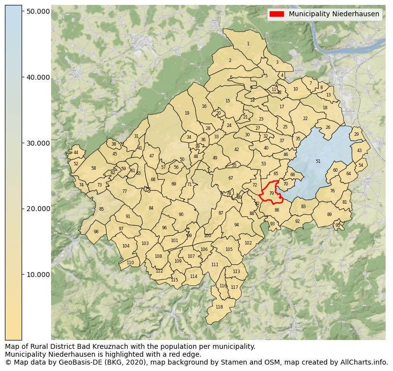
Map of Rural district Bad Kreuznach with the population per municipality.Municipality Niederhausen is highlighted with a red edge. The numbers at the map represent the following municipalities: 1: municipality Daxweiler, 2: municipality Seibersbach, 3: municipality Warmsroth, 4: municipality Roth, 5: municipality city Stromberg ...Show more... Map of Rural district Bad Kreuznach with the population per municipality.Municipality Niederhausen is highlighted with a red edge. The numbers at the map represent the following municipalities: 1: municipality Daxweiler, 2: municipality Seibersbach, 3: municipality Warmsroth, 4: municipality Roth, 5: municipality city Stromberg, 6: municipality Dörrebach, 7: municipality Rümmelsheim, 8: municipality Dorsheim, 9: municipality Schöneberg, 10: municipality Waldlaubersheim, 11: municipality Eckenroth, 12: municipality Schweppenhausen, 13: municipality Laubenheim, 14: municipality Hergenfeld, 15: municipality Spabrücken, 16: municipality Spall, 17: municipality Windesheim, 18: municipality Langenlonsheim, 19: municipality Winterbach, 20: municipality Münchwald, 21: municipality Dalberg, 22: municipality Guldental, 23: municipality Wallhausen, 24: municipality Argenschwang, 25: municipality Gutenberg, 26: municipality Bretzenheim, 27: municipality Sommerloch, 28: municipality Gebroth, 29: municipality Biebelsheim, 30: municipality Braunweiler, 31: municipality Schwarzerden, 32: municipality Sankt Katharinen, 33: municipality Allenfeld, 34: municipality Ippenschied, 35: municipality Hargesheim, 36: municipality Winterburg, 37: municipality Roxheim, 38: municipality Königsau, 39: municipality Rehbach, 40: municipality Mandel, 41: municipality Weitersborn, 42: municipality Sponheim, 43: municipality Pfaffen-Schwabenheim, 44: municipality Schneppenbach, 45: municipality Kellenbach, 46: municipality Rüdesheim, 47: municipality Seesbach, 48: municipality Daubach, 49: municipality Bockenau, 50: municipality city Bad Sobernheim, 51: municipality city Bad Kreuznach, 52: municipality Bruschied, 53: municipality Weinsheim, 54: municipality Pleitersheim, 55: municipality Burgsponheim, 56: municipality Auen, 57: municipality Langenthal, 58: municipality Hennweiler, 59: municipality Brauweiler, 60: municipality Hackenheim, 61: municipality Horbach, 62: municipality Heinzenberg, 63: municipality Simmertal, 64: municipality Volxheim, 65: municipality Hüffelsheim, 66: municipality Traisen, 67: municipality Waldböckelheim, 68: municipality Weiler bei Monzingen, 69: municipality Monzingen, 70: municipality Norheim, 71: municipality Nußbaum, 72: municipality Schloßböckelheim, 73: municipality Oberhausen bei Kirn, 74: municipality Hahnenbach, 75: municipality Martinstein, 76: municipality Frei-Laubersheim, 77: municipality Hochstetten-Dhaun, 78: municipality Oberstreit, 79: municipality Niederhausen, 80: municipality Boos, 81: municipality Neu-Bamberg, 82: municipality Oberhausen an der Nahe, 83: municipality Altenbamberg, 84: municipality Merxheim, 85: municipality city Kirn, 86: municipality Feilbingert, 87: municipality Staudernheim, 88: municipality Duchroth, 89: municipality Fürfeld, 90: municipality Meddersheim, 91: municipality Meckenbach, 92: municipality Hochstätten, 93: municipality Hallgarten, 94: municipality Odernheim am Glan, 95: municipality Tiefenthal, 96: municipality Kirschroth, 97: municipality Heimweiler, 98: municipality Bärenbach, 99: municipality Lauschied, 100: municipality Abtweiler, 101: municipality Bärweiler, 102: municipality Lettweiler, 103: municipality Limbach, 104: municipality Becherbach bei Kirn, 105: municipality Rehborn, 106: municipality Raumbach, 107: municipality Desloch, 108: municipality Hundsbach, 109: municipality Jeckenbach, 110: municipality Otzweiler, 111: municipality city Meisenheim, 112: municipality Schweinschied, 113: municipality Callbach, 114: municipality Breitenheim, 115: municipality Löllbach, 116: municipality Reiffelbach, 117: municipality Schmittweiler, 118: municipality Becherbach ...Show less...
The number of rooms per house (dwelling)
The number of rooms of the houses in the municipality Niederhausen
One moment please, your device is loading the charts...
Municipality Niederhausen, 2019, number of rooms per house.
The percentage shows the relative share of houses per category based on the numer of rooms: 1 to 2 rooms, 3 to 4 rooms or 5 rooms or more. This is based on the total number of rooms as identified for all dwellings in the municipality Niederhausen.
Data about more than 100 topics!
The table below shows data for more than 100 topics as most recently available for the municipality Niederhausen. Select a category to display the related topics:
| Business | Value | Unit | Year |
|---|---|---|---|
| Businesses | no data | Number | 2015 |
| Active persons | no data | Number | 2015 |
| Gross wages | no data | Euro | 2015 |
| Dwellings | Value | Unit | Year |
|---|---|---|---|
| Houses 1 room | 1 | Number | 2019 |
| Houses 2 rooms | 4 | Number | 2019 |
| Houses 3 rooms | 21 | Number | 2019 |
| Houses 4 rooms | 48 | Number | 2019 |
| Houses 5 rooms | 56 | Number | 2019 |
| Houses 6 rooms | 61 | Number | 2019 |
| Houses 7+ rooms | 85 | Number | 2019 |
| Houses 1-2 rooms | 5 | Number | 2019 |
| Houses 3-4 rooms | 69 | Number | 2019 |
| Houses 5+ rooms | 202 | Number | 2019 |
| 1-2 rooms | 2% | Percentage | 2019 |
| 3-4 rooms | 25% | Percentage | 2019 |
| 5+ rooms | 73% | Percentage | 2019 |
| Elections | Value | Unit | Year |
|---|---|---|---|
| Voters Bundestag | 489,00 | Number | 2017 |
| Voter turnout Bundestag | 77 | Number | 2017 |
| Votes valid Bundestag | 258 | Number | 2017 |
| Votes Bundestag CDU/CSU | 68 | Number | 2017 |
| Votes Bundestag SPD | 98 | Number | 2017 |
| Votes Bundestag GRÜNE | 19 | Number | 2017 |
| Votes Bundestag FDP | 33 | Number | 2017 |
| Votes Bundestag DIE LINKE | 11 | Number | 2017 |
| Votes Bundestag AfD | 16 | Number | 2017 |
| Votes Bundestag other parties | 13 | Number | 2017 |
| Votes Bundestag total | 258 | Number | 2017 |
| % Votes Bundestag CDU/CSU | 14% | Percentage | 2017 |
| % Votes Bundestag SPD | 20% | Percentage | 2017 |
| % Votes Bundestag GRÜNE | 4% | Percentage | 2017 |
| % Votes Bundestag FDP | 7% | Percentage | 2017 |
| % Votes Bundestag DIE LINKE | 2% | Percentage | 2017 |
| % Votes Bundestag AfD | 3% | Percentage | 2017 |
| % Votes Bundestag other parties | 3% | Percentage | 2017 |
| Employment | Value | Unit | Year |
|---|---|---|---|
| Employees | 257 | Number | 2019 |
| Employees male | 137 | Number | 2019 |
| Employees female | 120 | Number | 2019 |
| Employees foreigner | 34 | Number | 2019 |
| Employees male foreigner | 22 | Number | 2019 |
| Employees female foreigner | 12 | Number | 2019 |
| Unemployed | 15 | Number | 2018 |
| Unemployed foreigners | 2 | Number | 2018 |
| Unemployed severely disabled | 1 | Number | 2018 |
| Unemployed 15-20 | 0 | Number | 2018 |
| Unemployed 15-25 | 0 | Number | 2018 |
| Unemployed 55-65 | 6 | Number | 2018 |
| Unemployed long-term | 6 | Number | 2018 |
| % Unemployed | 3% | Percentage | 2018 |
| % Unemployed foreigners | 0% | Percentage of the population | 2018 |
| % Unemployed severely disabled | 0% | Percentage of the population | 2018 |
| % Unemployed 15-20 | 0% | Percentage of the population | 2018 |
| % Unemployed 15-25 | 0% | Percentage of the population | 2018 |
| % Unemployed 55-65 | 1% | Percentage of the population | 2018 |
| % Unemployed long-term | 1% | Percentage of the population | 2018 |
| Income | Value | Unit | Year |
|---|---|---|---|
| Income receivers | 281 | Number | 2015 |
| Income total | €10.216 | Euro | 2015 |
| Income tax | €1.469 | Euro | 2015 |
| Population | Value | Unit | Year |
|---|---|---|---|
| Population | 567 | Number | 2019 |
| Men | 288 | Number | 2019 |
| Women | 279 | Number | 2019 |
| % Men | 51% | Percentage | 2019 |
| % Women | 49% | Percentage | 2019 |
| 0-18 | 76 | Number | 2019 |
| 18-30 | 65 | Number | 2019 |
| 30-45 | 87 | Number | 2019 |
| 45-60 | 152 | Number | 2019 |
| 18-60 | 304 | Number | 2019 |
| 60-75 | 125 | Number | 2019 |
| 60+ | 187 | Number | 2019 |
| Average age | 48 | Average number | 2019 |
| Average age male | 46 | Average number | 2019 |
| Average age female | 49 | Average number | 2019 |
| Births | 4 | Number | 2018 |
| Births male | 2 | Number | 2018 |
| Births female | 2 | Number | 2018 |
| 1K Births | 7 | Number per 1000 inhabitants | 2018 |
| Deaths | 3 | Number | 2018 |
| Deaths male | 3 | Number | 2018 |
| Deaths female | 0 | Number | 2018 |
| 1K Deaths | 5 | Number | 2018 |
| 0-3 | 19 | Number | 2019 |
| Girls 0-3 | 11 | Number | 2019 |
| Boys 0-3 | 8 | Number | 2019 |
| 3-6 | 20 | Number | 2019 |
| Girls 3-6 | 7 | Number | 2019 |
| Boys 3-6 | 13 | Number | 2019 |
| 6-10 | 14 | Number | 2019 |
| 10-15 | 12 | Number | 2019 |
| 15-18 | 11 | Number | 2019 |
| 18-20 | 8 | Number | 2019 |
| 20-25 | 23 | Number | 2019 |
| 25-30 | 34 | Number | 2019 |
| 30-35 | 29 | Number | 2019 |
| 35-40 | 27 | Number | 2019 |
| 40-45 | 31 | Number | 2019 |
| 45-50 | 21 | Number | 2019 |
| 50-55 | 61 | Number | 2019 |
| 55-60 | 70 | Number | 2019 |
| 60-65 | 55 | Number | 2019 |
| 65-75 | 70 | Number | 2019 |
| Women 65-70 | 35 | Number | 2019 |
| Men 65-70 | 35 | Number | 2019 |
| 75+ | 62 | Number | 2019 |
| Women 75+ | 31 | Number | 2019 |
| Men 75+ | 31 | Number | 2019 |
| % 0-10 | 9% | Percentage | 2019 |
| % 10-18 | 4% | Percentage | 2019 |
| % 18-30 | 11% | Percentage | 2019 |
| % 30-45 | 15% | Percentage | 2019 |
| % 45-60 | 27% | Percentage | 2019 |
| % 60+ | 33% | Percentage | 2019 |
| Real estate | Value | Unit | Year |
|---|---|---|---|
| Property tax A revenue | €10.468 | Euro | 2018 |
| Property tax B revenue | €50.517 | Euro | 2018 |
| Trade tax actual revenue | €11.645 | Euro | 2018 |
| Property tax A basic amount | €3.432 | Euro | 2018 |
| Property tax B basic amount | €13.294 | Euro | 2018 |
| Trade tax basic amount | €3.064 | Euro | 2018 |
| Property tax A rate | €305 | Euro | 2018 |
| Property tax B rate | €380 | Euro | 2018 |
| Trade tax rate | €380 | Euro | 2018 |
| Real tax raising force | €86.757 | Euro | 2018 |
| Trade tax levy | €2.093 | Euro | 2018 |
| Trade tax net | €9.552 | Euro | 2018 |
| Community share in income tax | €287.166 | Euro | 2018 |
| Community share in sales tax | €9.791 | Euro | 2018 |
| Tax revenue | €381.621 | Euro | 2018 |
| Regional | Value | Unit | Year |
|---|---|---|---|
| Region code | 071335006070 | Code | 2019 |
| Region code 8 digits | 07133070 | Code | 07133070 |
| Sorting code | 071335006070 | Code | 071335006070 |
| Sorting code 8 digits | 07133070 | Code | 07133070 |
| Region name | Niederhausen | Name | 2019 |
| Regional level | 6 | Categorical type | 2019 |
| Region type | Municipality | Categorical type | 2019 |
| Region type detail | municipality | Categorical type | 2019 |
| Region name with type | municipality Niederhausen | Name | 2019 |
| Region name in German | Gemeinde Niederhausen | Name | 2019 |
| Direct subregions | no data | Number | 2019 |
| NUTS code | DEB14 | Code | 2019 |
| Area | 5 | Area in km² | 2019 |
| Religion | Value | Unit | Year |
|---|---|---|---|
| Roman Catholic church | 126 | Number | 2011 |
| Protestant church | 332 | Number | 2011 |
| Other or none | 81 | Number | 2011 |
| % Roman Catholic church | 23% | Percentage | 2011 |
| % Protestant church | 62% | Percentage | 2011 |
| % Other or none | 15% | Percentage | 2011 |
| Roman Catholic church German | 123 | Number | 2011 |
| Protestant church German | 332 | Number | 2011 |
| Other or none German | 81 | Number | 2011 |
| % Roman Catholic church German | 23% | Percentage | 2011 |
| % Protestant church German | 62% | Percentage | 2011 |
| % Other or none German Foreign | 15% | Percentage | 2011 |
| Roman Catholic church Foreign | 3 | Number | 2011 |
| Protestant church Foreign | 0 | Number | 2011 |
| Other or none Foreign | 0 | Number | 2011 |
| % Roman Catholic church Foreign | 100% | Percentage | 2011 |
| % Protestant church Foreign | 0% | Percentage | 2011 |
| % Other or none Foreign | 0% | Percentage | 2011 |
Open data sources used
Data is used from multiple German open data providers. See this description of the sources with the definitions of all regional topics.
Sources & definitionsUnder development
Work is in progress to add more information to this page
This page will be further expanded with more topics in clear graphs. This will be done in several iterations in the coming weeks.