Population numbers per year
The number of inhabitants in the municipality Pahlen
One moment please, your device is loading the charts...
Population numbers in the municipality Pahlen for the years 2009 thru 2019.
The number of inhabitants is the number of persons as registered in the population register on January 1st.
Population at the map of Pahlen
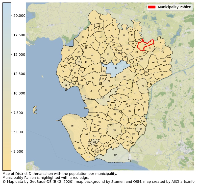
Map of District Dithmarschen with the population per municipality.Municipality Pahlen is highlighted with a red edge. The numbers at the map represent the following municipalities: 1: municipality Lehe, 2: municipality Sankt Annen, 3: municipality Lunden, 4: municipality Cleves, 5: municipality Bergewöhrden ...Show more... Map of District Dithmarschen with the population per municipality.Municipality Pahlen is highlighted with a red edge. The numbers at the map represent the following municipalities: 1: municipality Lehe, 2: municipality Sankt Annen, 3: municipality Lunden, 4: municipality Cleves, 5: municipality Bergewöhrden, 6: municipality Krempel, 7: municipality Groven, 8: municipality Delve, 9: municipality Schlichting, 10: municipality Hollingstedt, 11: municipality Hennstedt, 12: municipality Rehm-Flehde-Bargen, 13: municipality Karolinenkoog, 14: municipality Wallen, 15: municipality Fedderingen, 16: municipality Hemme, 17: municipality Tielenhemme, 18: municipality Glüsing, 19: municipality Pahlen, 20: municipality Wiemerstedt, 21: municipality Strübbel, 22: municipality Stelle-Wittenwurth, 23: municipality Dörpling, 24: municipality Linden, 25: municipality Wesselburenerkoog, 26: municipality Norderheistedt, 27: municipality Schülp, 28: municipality Schalkholz, 29: municipality Dellstedt, 30: municipality Hövede, 31: municipality Süderheistedt, 32: municipality Weddingstedt, 33: municipality Neuenkirchen, 34: municipality Barkenholm, 35: municipality Hillgroven, 36: municipality Norddeich, 37: municipality Tellingstedt, 38: municipality Westerborstel, 39: municipality Ostrohe, 40: municipality Wrohm, 41: municipality Wesseln, 42: municipality city Wesselburen, 43: municipality Oesterwurth, 44: municipality Süderdorf, 45: municipality Hellschen-Heringsand-Unterschaar, 46: municipality Welmbüttel, 47: municipality Süderdeich, 48: municipality Gaushorn, 49: municipality city Heide, 50: municipality Norderwöhrden, 51: municipality Osterrade, 52: municipality Lohe-Rickelshof, 53: municipality Wesselburener Deichhausen, 54: municipality Hedwigenkoog, 55: municipality Schrum, 56: municipality Immenstedt, 57: municipality Reinsbüttel, 58: municipality Offenbüttel, 59: municipality Nordhastedt, 60: municipality Arkebek, 61: municipality Wöhrden, 62: municipality Bunsoh, 63: municipality Oesterdeichstrich, 64: municipality Lieth, 65: municipality Westerdeichstrich, 66: municipality Friedrichsgabekoog, 67: municipality Hemmingstedt, 68: municipality Odderade, 69: municipality Wennbüttel, 70: municipality Büsumer Deichhausen, 71: municipality Büsum, 72: municipality Warwerort, 73: municipality Albersdorf, 74: municipality Epenwöhrden, 75: municipality Sarzbüttel, 76: municipality Nordermeldorf, 77: municipality Tensbüttel-Röst, 78: municipality city Meldorf, 79: municipality Bargenstedt, 80: municipality Nindorf, 81: municipality Schafstedt, 82: municipality Krumstedt, 83: municipality Wolmersdorf, 84: municipality Elpersbüttel, 85: municipality Eggstedt, 86: municipality Süderhastedt, 87: municipality Windbergen, 88: municipality Busenwurth, 89: municipality Großenrade, 90: municipality Frestedt, 91: municipality Gudendorf, 92: municipality Hochdonn, 93: municipality Barlt, 94: municipality Brickeln, 95: municipality Friedrichskoog, 96: municipality Trennewurth, 97: municipality Quickborn, 98: municipality Burg (Dithmarschen), 99: municipality Sankt Michaelisdonn, 100: municipality Buchholz, 101: municipality Kronprinzenkoog, 102: municipality Helse, 103: municipality Volsemenhusen, 104: municipality Kuden, 105: municipality Dingen, 106: municipality city Marne, 107: municipality Marnerdeich, 108: municipality Eddelak, 109: municipality Averlak, 110: municipality Ramhusen, 111: municipality Diekhusen-Fahrstedt, 112: municipality Kaiser-Wilhelm-Koog, 113: municipality Schmedeswurth, 114: municipality Neufeld, 115: municipality city Brunsbüttel, 116: municipality Neufelderkoog ...Show less...
The number of rooms per house (dwelling)
The number of rooms of the houses in the municipality Pahlen
One moment please, your device is loading the charts...
Municipality Pahlen, 2019, number of rooms per house.
The percentage shows the relative share of houses per category based on the numer of rooms: 1 to 2 rooms, 3 to 4 rooms or 5 rooms or more. This is based on the total number of rooms as identified for all dwellings in the municipality Pahlen.
Data about more than 100 topics!
The table below shows data for more than 100 topics as most recently available for the municipality Pahlen. Select a category to display the related topics:
| Business | Value | Unit | Year |
|---|---|---|---|
| Businesses | 2 | Number | 2017 |
| Active persons | 0 | Number | 2017 |
| Gross wages | €0 | Euro | 2017 |
| Dwellings | Value | Unit | Year |
|---|---|---|---|
| Houses 1 room | 0 | Number | 2019 |
| Houses 2 rooms | 20 | Number | 2019 |
| Houses 3 rooms | 87 | Number | 2019 |
| Houses 4 rooms | 84 | Number | 2019 |
| Houses 5 rooms | 122 | Number | 2019 |
| Houses 6 rooms | 102 | Number | 2019 |
| Houses 7+ rooms | 134 | Number | 2019 |
| Houses 1-2 rooms | 20 | Number | 2019 |
| Houses 3-4 rooms | 171 | Number | 2019 |
| Houses 5+ rooms | 358 | Number | 2019 |
| 1-2 rooms | 4% | Percentage | 2019 |
| 3-4 rooms | 31% | Percentage | 2019 |
| 5+ rooms | 65% | Percentage | 2019 |
| Elections | Value | Unit | Year |
|---|---|---|---|
| Voters Bundestag | 934,00 | Number | 2017 |
| Voter turnout Bundestag | 62 | Number | 2017 |
| Votes valid Bundestag | 569 | Number | 2017 |
| Votes Bundestag CDU/CSU | 256 | Number | 2017 |
| Votes Bundestag SPD | 103 | Number | 2017 |
| Votes Bundestag GRÜNE | 35 | Number | 2017 |
| Votes Bundestag FDP | 80 | Number | 2017 |
| Votes Bundestag DIE LINKE | 23 | Number | 2017 |
| Votes Bundestag AfD | 55 | Number | 2017 |
| Votes Bundestag other parties | 17 | Number | 2017 |
| Votes Bundestag total | 569 | Number | 2017 |
| % Votes Bundestag CDU/CSU | 27% | Percentage | 2017 |
| % Votes Bundestag SPD | 11% | Percentage | 2017 |
| % Votes Bundestag GRÜNE | 4% | Percentage | 2017 |
| % Votes Bundestag FDP | 9% | Percentage | 2017 |
| % Votes Bundestag DIE LINKE | 2% | Percentage | 2017 |
| % Votes Bundestag AfD | 6% | Percentage | 2017 |
| % Votes Bundestag other parties | 2% | Percentage | 2017 |
| Employment | Value | Unit | Year |
|---|---|---|---|
| Employees | 435 | Number | 2019 |
| Employees male | 232 | Number | 2019 |
| Employees female | 203 | Number | 2019 |
| Employees foreigner | 3 | Number | 2019 |
| Employees male foreigner | 3 | Number | 2019 |
| Employees female foreigner | 0 | Number | 2019 |
| Unemployed | 34 | Number | 2018 |
| Unemployed foreigners | 1 | Number | 2018 |
| Unemployed severely disabled | 2 | Number | 2018 |
| Unemployed 15-20 | 1 | Number | 2018 |
| Unemployed 15-25 | 5 | Number | 2018 |
| Unemployed 55-65 | 6 | Number | 2018 |
| Unemployed long-term | 8 | Number | 2018 |
| % Unemployed | 3% | Percentage | 2018 |
| % Unemployed foreigners | 0% | Percentage of the population | 2018 |
| % Unemployed severely disabled | 0% | Percentage of the population | 2018 |
| % Unemployed 15-20 | 0% | Percentage of the population | 2018 |
| % Unemployed 15-25 | 0% | Percentage of the population | 2018 |
| % Unemployed 55-65 | 1% | Percentage of the population | 2018 |
| % Unemployed long-term | 1% | Percentage of the population | 2018 |
| Income | Value | Unit | Year |
|---|---|---|---|
| Income receivers | 522 | Number | 2015 |
| Income total | €15.295 | Euro | 2015 |
| Income tax | €1.977 | Euro | 2015 |
| Population | Value | Unit | Year |
|---|---|---|---|
| Population | 1.149 | Number | 2019 |
| Men | 577 | Number | 2019 |
| Women | 572 | Number | 2019 |
| % Men | 50% | Percentage | 2019 |
| % Women | 50% | Percentage | 2019 |
| 0-18 | 215 | Number | 2019 |
| 18-30 | 133 | Number | 2019 |
| 30-45 | 169 | Number | 2019 |
| 45-60 | 308 | Number | 2019 |
| 18-60 | 610 | Number | 2019 |
| 60-75 | 196 | Number | 2019 |
| 60+ | 324 | Number | 2019 |
| Average age | 45 | Average number | 2019 |
| Average age male | 43 | Average number | 2019 |
| Average age female | 46 | Average number | 2019 |
| Births | 10 | Number | 2018 |
| Births male | 7 | Number | 2018 |
| Births female | 3 | Number | 2018 |
| 1K Births | 9 | Number per 1000 inhabitants | 2018 |
| Deaths | 23 | Number | 2018 |
| Deaths male | 11 | Number | 2018 |
| Deaths female | 12 | Number | 2018 |
| 1K Deaths | 20 | Number | 2018 |
| 0-3 | 25 | Number | 2019 |
| Girls 0-3 | 10 | Number | 2019 |
| Boys 0-3 | 15 | Number | 2019 |
| 3-6 | 33 | Number | 2019 |
| Girls 3-6 | 18 | Number | 2019 |
| Boys 3-6 | 15 | Number | 2019 |
| 6-10 | 43 | Number | 2019 |
| 10-15 | 62 | Number | 2019 |
| 15-18 | 52 | Number | 2019 |
| 18-20 | 33 | Number | 2019 |
| 20-25 | 50 | Number | 2019 |
| 25-30 | 50 | Number | 2019 |
| 30-35 | 55 | Number | 2019 |
| 35-40 | 52 | Number | 2019 |
| 40-45 | 62 | Number | 2019 |
| 45-50 | 101 | Number | 2019 |
| 50-55 | 124 | Number | 2019 |
| 55-60 | 83 | Number | 2019 |
| 60-65 | 67 | Number | 2019 |
| 65-75 | 129 | Number | 2019 |
| Women 65-70 | 66 | Number | 2019 |
| Men 65-70 | 63 | Number | 2019 |
| 75+ | 128 | Number | 2019 |
| Women 75+ | 69 | Number | 2019 |
| Men 75+ | 59 | Number | 2019 |
| % 0-10 | 9% | Percentage | 2019 |
| % 10-18 | 10% | Percentage | 2019 |
| % 18-30 | 12% | Percentage | 2019 |
| % 30-45 | 15% | Percentage | 2019 |
| % 45-60 | 27% | Percentage | 2019 |
| % 60+ | 28% | Percentage | 2019 |
| Real estate | Value | Unit | Year |
|---|---|---|---|
| Property tax A revenue | €15.567 | Euro | 2018 |
| Property tax B revenue | €122.216 | Euro | 2018 |
| Trade tax actual revenue | €370.332 | Euro | 2018 |
| Property tax A basic amount | €4.942 | Euro | 2018 |
| Property tax B basic amount | €38.799 | Euro | 2018 |
| Trade tax basic amount | €115.729 | Euro | 2018 |
| Property tax A rate | €315 | Euro | 2018 |
| Property tax B rate | €315 | Euro | 2018 |
| Trade tax rate | €320 | Euro | 2018 |
| Real tax raising force | €665.323 | Euro | 2018 |
| Trade tax levy | €79.040 | Euro | 2018 |
| Trade tax net | €291.292 | Euro | 2018 |
| Community share in income tax | €317.875 | Euro | 2018 |
| Community share in sales tax | €39.972 | Euro | 2018 |
| Tax revenue | €944.130 | Euro | 2018 |
| Regional | Value | Unit | Year |
|---|---|---|---|
| Region code | 010515169088 | Code | 2019 |
| Region code 8 digits | 01051088 | Code | 01051088 |
| Sorting code | 010515169088 | Code | 010515169088 |
| Sorting code 8 digits | 01051088 | Code | 01051088 |
| Region name | Pahlen | Name | 2019 |
| Regional level | 6 | Categorical type | 2019 |
| Region type | Municipality | Categorical type | 2019 |
| Region type detail | municipality | Categorical type | 2019 |
| Region name with type | municipality Pahlen | Name | 2019 |
| Region name in German | Gemeinde Pahlen | Name | 2019 |
| Direct subregions | no data | Number | 2019 |
| NUTS code | DEF05 | Code | 2019 |
| Area | 11 | Area in km² | 2019 |
| Religion | Value | Unit | Year |
|---|---|---|---|
| Roman Catholic church | 29 | Number | 2011 |
| Protestant church | 902 | Number | 2011 |
| Other or none | 279 | Number | 2011 |
| % Roman Catholic church | 2% | Percentage | 2011 |
| % Protestant church | 75% | Percentage | 2011 |
| % Other or none | 23% | Percentage | 2011 |
| Roman Catholic church German | 26 | Number | 2011 |
| Protestant church German | 899 | Number | 2011 |
| Other or none German | 270 | Number | 2011 |
| % Roman Catholic church German | 2% | Percentage | 2011 |
| % Protestant church German | 75% | Percentage | 2011 |
| % Other or none German Foreign | 23% | Percentage | 2011 |
| Roman Catholic church Foreign | 3 | Number | 2011 |
| Protestant church Foreign | 3 | Number | 2011 |
| Other or none Foreign | 9 | Number | 2011 |
| % Roman Catholic church Foreign | 20% | Percentage | 2011 |
| % Protestant church Foreign | 20% | Percentage | 2011 |
| % Other or none Foreign | 60% | Percentage | 2011 |
Open data sources used
Data is used from multiple German open data providers. See this description of the sources with the definitions of all regional topics.
Sources & definitionsUnder development
Work is in progress to add more information to this page
This page will be further expanded with more topics in clear graphs. This will be done in several iterations in the coming weeks.