Population numbers per year
The number of inhabitants in the municipality Tramm
One moment please, your device is loading the charts...
Population numbers in the municipality Tramm for the years 2012 thru 2019.
The number of inhabitants is the number of persons as registered in the population register on January 1st.
Population at the map of Tramm
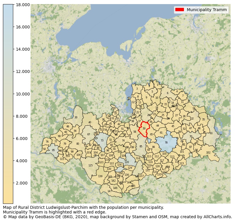
Map of Rural district Ludwigslust-Parchim with the population per municipality.Municipality Tramm is highlighted with a red edge. The numbers at the map represent the following municipalities: 1: municipality Blankenberg, 2: municipality Kloster Tempzin, 3: municipality Dobin am See, 4: municipality Witzin, 5: municipality city Brüel ...Show more... Map of Rural district Ludwigslust-Parchim with the population per municipality.Municipality Tramm is highlighted with a red edge. The numbers at the map represent the following municipalities: 1: municipality Blankenberg, 2: municipality Kloster Tempzin, 3: municipality Dobin am See, 4: municipality Witzin, 5: municipality city Brüel, 6: municipality city Sternberg, 7: municipality Mustin, 8: municipality Cambs, 9: municipality Kuhlen-Wendorf, 10: municipality Weitendorf, 11: municipality Borkow, 12: municipality Leezen, 13: municipality Langen Brütz, 14: municipality Dabel, 15: municipality Kobrow, 16: municipality Gneven, 17: municipality Hohen Pritz, 18: municipality Demen, 19: municipality Dobbertin, 20: municipality Wittenförden, 21: municipality Pinnow, 22: municipality Klein Rogahn, 23: municipality Barnin, 24: municipality Raben Steinfeld, 25: municipality Bülow, 26: municipality city Crivitz, 27: municipality Mestlin, 28: municipality Techentin, 29: municipality Zülow, 30: municipality city Zarrentin am Schaalsee, 31: municipality Stralendorf, 32: municipality city Goldberg, 33: municipality Pampow, 34: municipality Zölkow, 35: municipality Neu Poserin, 36: municipality Dümmer, 37: municipality Sukow, 38: municipality Plate, 39: municipality Zapel, 40: municipality Wittendörp, 41: municipality Warsow, 42: municipality Holthusen, 43: municipality Schossin, 44: municipality Friedrichsruhe, 45: municipality Obere Warnow, 46: municipality Lüttow-Valluhn, 47: municipality Passow, 48: municipality Gallin-Kuppentin, 49: municipality Lübesse, 50: municipality Tramm, 51: municipality Sülstorf, 52: municipality Werder, 53: municipality Hülseburg, 54: municipality Gammelin, 55: municipality Bandenitz, 56: municipality Kogel, 57: municipality Alt Zachun, 58: municipality Banzkow, 59: municipality Granzin, 60: municipality Gallin, 61: municipality Domsühl, 62: municipality Barkhagen, 63: municipality city Plau am See, 64: municipality Bobzin, 65: municipality Lewitzrand, 66: municipality Uelitz, 67: municipality city Wittenburg, 68: municipality Hoort, 69: municipality Greven, 70: municipality city Lübz, 71: municipality Rom, 72: municipality Kirch Jesar, 73: municipality city Hagenow, 74: municipality Rastow, 75: municipality Kritzow, 76: municipality Schwanheide, 77: municipality Gresse, 78: municipality city Parchim, 79: municipality Bengerstorf, 80: municipality Vellahn, 81: municipality Gischow, 82: municipality Setzin, 83: municipality Moraas, 84: municipality Toddin, 85: municipality city Neustadt-Glewe, 86: municipality Spornitz, 87: municipality Kreien, 88: municipality Lüblow, 89: municipality Wöbbelin, 90: municipality Pätow-Steegen, 91: municipality Strohkirchen, 92: municipality Nostorf, 93: municipality Brenz, 94: municipality Gehlsbach, 95: municipality city Boizenburg/Elbe, 96: municipality Kuhstorf, 97: municipality Tessin b. Boizenburg, 98: municipality Neu Gülze, 99: municipality Dersenow, 100: municipality Picher, 101: municipality Siggelkow, 102: municipality Ganzlin, 103: municipality Pritzier, 104: municipality Warlitz, 105: municipality Groß Godems, 106: municipality Brahlstorf, 107: municipality Redefin, 108: municipality Bresegard bei Picher, 109: municipality Warlow, 110: municipality Besitz, 111: municipality Blievenstorf, 112: municipality Stolpe, 113: municipality Tessenow, 114: municipality Groß Laasch, 115: municipality Teldau, 116: municipality Groß Krams, 117: municipality Karrenzin, 118: municipality Marnitz, 119: municipality Muchow, 120: municipality city Ludwigslust, 121: municipality Belsch, 122: municipality Alt Krenzlin, 123: municipality Suckow, 124: municipality Göhlen, 125: municipality city Lübtheen, 126: municipality Möllenbeck, 127: municipality Zierzow, 128: municipality Ziegendorf, 129: municipality Karstädt, 130: municipality Leussow, 131: municipality Prislich, 132: municipality Brunow, 133: municipality Balow, 134: municipality Bresegard bei Eldena, 135: municipality Dambeck, 136: municipality Eldena, 137: municipality Kremmin, 138: municipality Karenz, 139: municipality Vielank, 140: municipality city Grabow, 141: municipality Grebs-Niendorf, 142: municipality Malliß, 143: municipality Malk Göhren, 144: municipality Gorlosen, 145: municipality Milow, 146: municipality Neu Kaliß, 147: municipality city Dömitz ...Show less...
The number of rooms per house (dwelling)
The number of rooms of the houses in the municipality Tramm
One moment please, your device is loading the charts...
Municipality Tramm, 2019, number of rooms per house.
The percentage shows the relative share of houses per category based on the numer of rooms: 1 to 2 rooms, 3 to 4 rooms or 5 rooms or more. This is based on the total number of rooms as identified for all dwellings in the municipality Tramm.
Data about more than 100 topics!
The table below shows data for more than 100 topics as most recently available for the municipality Tramm. Select a category to display the related topics:
| Business | Value | Unit | Year |
|---|---|---|---|
| Businesses | 1 | Number | 2017 |
| Active persons | 0 | Number | 2017 |
| Gross wages | €0 | Euro | 2017 |
| Dwellings | Value | Unit | Year |
|---|---|---|---|
| Houses 1 room | 3 | Number | 2019 |
| Houses 2 rooms | 14 | Number | 2019 |
| Houses 3 rooms | 52 | Number | 2019 |
| Houses 4 rooms | 107 | Number | 2019 |
| Houses 5 rooms | 113 | Number | 2019 |
| Houses 6 rooms | 71 | Number | 2019 |
| Houses 7+ rooms | 65 | Number | 2019 |
| Houses 1-2 rooms | 17 | Number | 2019 |
| Houses 3-4 rooms | 159 | Number | 2019 |
| Houses 5+ rooms | 249 | Number | 2019 |
| 1-2 rooms | 4% | Percentage | 2019 |
| 3-4 rooms | 37% | Percentage | 2019 |
| 5+ rooms | 59% | Percentage | 2019 |
| Elections | Value | Unit | Year |
|---|---|---|---|
| Voters Bundestag | 763,00 | Number | 2017 |
| Voter turnout Bundestag | 61 | Number | 2017 |
| Votes valid Bundestag | 456 | Number | 2017 |
| Votes Bundestag CDU/CSU | 167 | Number | 2017 |
| Votes Bundestag SPD | 73 | Number | 2017 |
| Votes Bundestag GRÜNE | 12 | Number | 2017 |
| Votes Bundestag FDP | 32 | Number | 2017 |
| Votes Bundestag DIE LINKE | 62 | Number | 2017 |
| Votes Bundestag AfD | 89 | Number | 2017 |
| Votes Bundestag other parties | 21 | Number | 2017 |
| Votes Bundestag total | 456 | Number | 2017 |
| % Votes Bundestag CDU/CSU | 22% | Percentage | 2017 |
| % Votes Bundestag SPD | 10% | Percentage | 2017 |
| % Votes Bundestag GRÜNE | 2% | Percentage | 2017 |
| % Votes Bundestag FDP | 4% | Percentage | 2017 |
| % Votes Bundestag DIE LINKE | 8% | Percentage | 2017 |
| % Votes Bundestag AfD | 12% | Percentage | 2017 |
| % Votes Bundestag other parties | 3% | Percentage | 2017 |
| Employment | Value | Unit | Year |
|---|---|---|---|
| Employees | 373 | Number | 2019 |
| Employees male | 188 | Number | 2019 |
| Employees female | 185 | Number | 2019 |
| Employees foreigner | 0 | Number | 2019 |
| Employees male foreigner | 0 | Number | 2019 |
| Employees female foreigner | 0 | Number | 2019 |
| Unemployed | 27 | Number | 2018 |
| Unemployed foreigners | 0 | Number | 2018 |
| Unemployed severely disabled | 3 | Number | 2018 |
| Unemployed 15-20 | 0 | Number | 2018 |
| Unemployed 15-25 | 0 | Number | 2018 |
| Unemployed 55-65 | 16 | Number | 2018 |
| Unemployed long-term | 10 | Number | 2018 |
| % Unemployed | 3% | Percentage | 2018 |
| % Unemployed foreigners | 0% | Percentage of the population | 2018 |
| % Unemployed severely disabled | 0% | Percentage of the population | 2018 |
| % Unemployed 15-20 | 0% | Percentage of the population | 2018 |
| % Unemployed 15-25 | 0% | Percentage of the population | 2018 |
| % Unemployed 55-65 | 2% | Percentage of the population | 2018 |
| % Unemployed long-term | 1% | Percentage of the population | 2018 |
| Income | Value | Unit | Year |
|---|---|---|---|
| Income receivers | 420 | Number | 2015 |
| Income total | €13.267 | Euro | 2015 |
| Income tax | €1.694 | Euro | 2015 |
| Population | Value | Unit | Year |
|---|---|---|---|
| Population | 915 | Number | 2019 |
| Men | 461 | Number | 2019 |
| Women | 454 | Number | 2019 |
| % Men | 50% | Percentage | 2019 |
| % Women | 50% | Percentage | 2019 |
| 0-18 | 150 | Number | 2019 |
| 18-30 | 59 | Number | 2019 |
| 30-45 | 176 | Number | 2019 |
| 45-60 | 238 | Number | 2019 |
| 18-60 | 473 | Number | 2019 |
| 60-75 | 203 | Number | 2019 |
| 60+ | 292 | Number | 2019 |
| Average age | 47 | Average number | 2019 |
| Average age male | 47 | Average number | 2019 |
| Average age female | 48 | Average number | 2019 |
| Births | 4 | Number | 2018 |
| Births male | 4 | Number | 2018 |
| Births female | 0 | Number | 2018 |
| 1K Births | 4 | Number per 1000 inhabitants | 2018 |
| Deaths | 7 | Number | 2018 |
| Deaths male | 6 | Number | 2018 |
| Deaths female | 1 | Number | 2018 |
| 1K Deaths | 8 | Number | 2018 |
| 0-3 | 17 | Number | 2019 |
| Girls 0-3 | 6 | Number | 2019 |
| Boys 0-3 | 11 | Number | 2019 |
| 3-6 | 27 | Number | 2019 |
| Girls 3-6 | 17 | Number | 2019 |
| Boys 3-6 | 10 | Number | 2019 |
| 6-10 | 38 | Number | 2019 |
| 10-15 | 43 | Number | 2019 |
| 15-18 | 25 | Number | 2019 |
| 18-20 | 17 | Number | 2019 |
| 20-25 | 9 | Number | 2019 |
| 25-30 | 33 | Number | 2019 |
| 30-35 | 45 | Number | 2019 |
| 35-40 | 58 | Number | 2019 |
| 40-45 | 73 | Number | 2019 |
| 45-50 | 49 | Number | 2019 |
| 50-55 | 83 | Number | 2019 |
| 55-60 | 106 | Number | 2019 |
| 60-65 | 93 | Number | 2019 |
| 65-75 | 110 | Number | 2019 |
| Women 65-70 | 57 | Number | 2019 |
| Men 65-70 | 53 | Number | 2019 |
| 75+ | 89 | Number | 2019 |
| Women 75+ | 47 | Number | 2019 |
| Men 75+ | 42 | Number | 2019 |
| % 0-10 | 9% | Percentage | 2019 |
| % 10-18 | 7% | Percentage | 2019 |
| % 18-30 | 6% | Percentage | 2019 |
| % 30-45 | 19% | Percentage | 2019 |
| % 45-60 | 26% | Percentage | 2019 |
| % 60+ | 32% | Percentage | 2019 |
| Real estate | Value | Unit | Year |
|---|---|---|---|
| Property tax A revenue | no data | Euro | no data |
| Property tax B revenue | no data | Euro | no data |
| Trade tax actual revenue | no data | Euro | no data |
| Property tax A basic amount | no data | Euro | no data |
| Property tax B basic amount | no data | Euro | no data |
| Trade tax basic amount | no data | Euro | no data |
| Property tax A rate | no data | Euro | no data |
| Property tax B rate | no data | Euro | no data |
| Trade tax rate | no data | Euro | no data |
| Real tax raising force | no data | Euro | no data |
| Trade tax levy | no data | Euro | no data |
| Trade tax net | no data | Euro | no data |
| Community share in income tax | no data | Euro | no data |
| Community share in sales tax | no data | Euro | no data |
| Tax revenue | no data | Euro | no data |
| Regional | Value | Unit | Year |
|---|---|---|---|
| Region code | 130765668140 | Code | 2019 |
| Region code 8 digits | 13076140 | Code | 13076140 |
| Sorting code | 130765668140 | Code | 130765668140 |
| Sorting code 8 digits | 13076140 | Code | 13076140 |
| Region name | Tramm | Name | 2019 |
| Regional level | 6 | Categorical type | 2019 |
| Region type | Municipality | Categorical type | 2019 |
| Region type detail | municipality | Categorical type | 2019 |
| Region name with type | municipality Tramm | Name | 2019 |
| Region name in German | Gemeinde Tramm | Name | 2019 |
| Direct subregions | no data | Number | 2019 |
| NUTS code | DE80O | Code | 2019 |
| Area | 42 | Area in km² | 2019 |
| Religion | Value | Unit | Year |
|---|---|---|---|
| Roman Catholic church | no data | Number | no data |
| Protestant church | no data | Number | no data |
| Other or none | no data | Number | no data |
| % Roman Catholic church | no data | Percentage | no data |
| % Protestant church | no data | Percentage | no data |
| % Other or none | no data | Percentage | no data |
| Roman Catholic church German | no data | Number | no data |
| Protestant church German | no data | Number | no data |
| Other or none German | no data | Number | no data |
| % Roman Catholic church German | no data | Percentage | no data |
| % Protestant church German | no data | Percentage | no data |
| % Other or none German Foreign | no data | Percentage | no data |
| Roman Catholic church Foreign | no data | Number | no data |
| Protestant church Foreign | no data | Number | no data |
| Other or none Foreign | no data | Number | no data |
| % Roman Catholic church Foreign | no data | Percentage | no data |
| % Protestant church Foreign | no data | Percentage | no data |
| % Other or none Foreign | no data | Percentage | no data |
Open data sources used
Data is used from multiple German open data providers. See this description of the sources with the definitions of all regional topics.
Sources & definitionsUnder development
Work is in progress to add more information to this page
This page will be further expanded with more topics in clear graphs. This will be done in several iterations in the coming weeks.